Post your rides

MikeInAZ
Posts: 483 Member
If you use a GPS while riding, post the trail/track! I use MyTracks on my Android phone while riding! There are similar Aps for iPhone. Evil has his Garmin. Etc...
http://g.co/maps/upx9k
McDowell Mts. Competitive Loop and Sport Track
Created by My Tracks on Android.
Total Distance: 18.75 km (11.7 mi)
Total Time: 1:55:22
Moving Time: 1:24:27
Average Speed: 9.75 km/h (6.1 mi/h)
Average Moving Speed: 13.32 km/h (8.3 mi/h)
Max Speed: 34.25 km/h (21.3 mi/h)
Min Elevation: 443 m (1453 ft)
Max Elevation: 517 m (1696 ft)
Elevation Gain: 358 m (1176 ft)
Max Grade: 7 %
Min Grade: -12 %
Recorded: Sat Oct 29 08:41:59 MST 2011
0
Replies
-
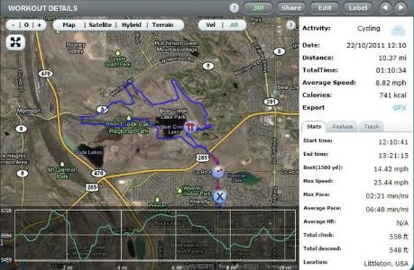
Here's my usual "get out of the house and ride some dirt" trails. about 90% dirt, less the street riding to get there:
 0
0 -
Jskaggs, What application is that? I use Strava.
 0
0 -
It's SportyPal.(http://www.sportypal.com) The app is one of the few GPS trackers that will run on my stupid and obsolete Blackberry, but it's a pretty good app for tracking time, distance, and pace. Elevation data isn't good, so if I want accurate elev. mapping, I download a GPX from the website and import it into Topo Explorer.
Edited to add: It works for running, biking, skiing, and a bunch of other stuff too.0 -
This is known as Trail 100, in the Phoenix Mt Preserve. Although this was a short ride (about 7.5miles) it's pretty technical. There's a lot of loose rocks, climbing and some wicked downhill.
http://g.co/maps/cjw2w
2011-11-12 07:32 (End)
Updated yesterday
Created by My Tracks on Android.
Total Distance: 12.36 km (7.7 mi)
Total Time: 1:54:26
Moving Time: 1:00:56
Average Speed: 6.48 km/h (4.0 mi/h)
Average Moving Speed: 12.17 km/h (7.6 mi/h)
Max Speed: 39.60 km/h (24.6 mi/h)
Min Elevation: 401 m (1317 ft)
Max Elevation: 491 m (1612 ft)
Elevation Gain: 252 m (826 ft)
Max Grade: 10 %
Min Grade: -13 %
Recorded: Sat Nov 12 07:32:27 MST 20110 -
I use Logyourrun.
This is my normal ride. I live in flat country and my balance sucks, so I pretty much stick to the streets now.
http://www.logyourrun.com/showroute/W6QWpgmEzAKEqT0 -
I use Strava and Garmin Connect, both are great. I would stay away from Garmin Training Center, it's fine as a program but being non-web based, if your HD crashes you could possibly lose all your data.0
-
Here's today's ride: http://sportypal.com/Workouts/Details/1741716
About 8 miles of paved/street to get to the good stuff, then a couple miles of le dirt.0 -
Just joined group. No ride today (rain). This my 11/14 ride:
http://www.endomondo.com/workouts/tKv92CdScb8
I use my Garmin Forerunner 305 and Endomondo0 -
Nice ride, looks dangerous (lots of busy roads??) I'll stick to the dirt!0
-
 0
0 -
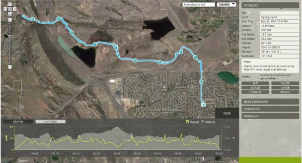
Well, the snow we got last week is melting away, and the weather's nice, so I got the bike out to give her a good flogging. Unfortunately, the trails are still muddy, so I kept it to the paved paths. Even the one guy I ran across who was riding the trails on a Pugsley was having trouble, with a couple pounds of mud caked to each wheel. I'm not one to beat up my local trails. Anyhow, here's the ride:

http://www.endomondo.com/workouts/tKOzlvAMVS40 -
Some of my favorite trails: http://g.co/maps/9wfna
Fortunate for me, all but one start in my back yard!0
This discussion has been closed.


