Space
Replies
-
NuSTAR Stares at the Sun

Flaring, active regions of our sun are highlighted in this image combining observations from several telescopes. High-energy X-rays from NASA's Nuclear Spectroscopic Telescope Array (NuSTAR) are shown in blue; low-energy X-rays from Japan's Hinode spacecraft are green; and extreme ultraviolet light from NASA's Solar Dynamics Observatory (SDO) is yellow and red. All three telescopes captured their solar images around the same time on April 29, 2015. The NuSTAR image is a mosaic made from combining smaller images.
The active regions across the sun's surface contain material heated to several millions of degrees. The blue-white areas showing the NuSTAR data pinpoint the most energetic spots. During the observations, microflares went off, which are smaller versions of the larger flares that also erupt from the sun's surface. The microflares rapidly release energy and heat the material in the active regions. NuSTAR typically stares deeper into the cosmos to observe X-rays from supernovas, black holes and other extreme objects. But it can also look safely at the sun and capture images of its high-energy X-rays with more sensitivity than before.
Scientists plan to continue to study the sun with NuSTAR to learn more about microflares, as well as hypothesized nanoflares, which are even smaller. In this image, the NuSTAR data shows X-rays with energies between 2 and 6 kiloelectron volts; the Hinode data, which is from the X-ray Telescope instrument, has energies of 0.2 to 2.4 kiloelectron volts; and the Solar Dynamics Observatory data, taken using the Atmospheric Imaging Assembly instrument, shows extreme ultraviolet light with wavelengths of 171 and 193 Angstroms.
Note the green Hinode image frame edge does not extend as far as the SDO ultraviolet image, resulting in the green portion of the image being truncated on the right and left sides.
2 -
Hubble Shows Light Echo Expanding from Exploded Star

Light from a supernova explosion in the nearby starburst galaxy M82 is reverberating off a huge dust cloud in interstellar space.2 -
-
Celebrating 28 Years of the Hubble Space Telescope

This colorful image, taken by NASA’s Hubble Space Telescope, celebrates the Earth-orbiting observatory’s 28th anniversary of viewing the heavens, giving us a window seat to the universe’s extraordinary stellar tapestry of birth and destruction.3 -
Celebrating 28 Years of the Hubble Space Telescope
This colorful image, taken by NASA’s Hubble Space Telescope, celebrates the Earth-orbiting observatory’s 28th anniversary of viewing the heavens, giving us a window seat to the universe’s extraordinary stellar tapestry of birth and destruction.
Ill be re-visiting this thread later... once my brownies are out of the oven") 2
2 -
Kepler has been amazing to discover new planets and make some incredible moves forward in space exploration, but yesterday TESS) launched ushering a new level of excitement. Also waiting for and the James Webb Space Telescope launch in just a few years. the details and light gather capabilities will reveal 10 fold what Kepler has been able to do.
Can't wait to see the images and data coming back.
https://svs.gsfc.nasa.gov/Gallery/TESS.html1 -

2 -

2 -

Astronauts aboard the International Space Station captured this photo while flying over the western United States. The wide field of view stretches from the Sierra Nevada of California to the Columbia Plateau of Oregon and the Snake River Valley of Idaho. Lake Tahoe is nestled on the border of California and Nevada.3 -

(March 25, 2018) --- This view of Cuba looks from east to west and reaches the cities of Santiago de Cuba on its west coast and Havana on its east coast. The sun's glint is reflected off the Caribbean Sea on Cuba's southern coast.3 -

(March 24, 2018) --- Storm clouds blanket an area of South Africa just inland from its eastern coast on the Indian Ocean.3 -
Jupiter’s Swirling Cloud Formations

See swirling cloud formations in the northern area of Jupiter's north temperate belt in this new view taken by NASA’s Juno spacecraft.2 -
-
This is the Surface of a Comet
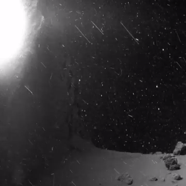
Back in 2014, the Rosetta spacecraft captured the world’s imagination by arriving at a comet and snapping the first-ever photos of a comet’s surface. Now here’s something that’s even better: a series of photos turned into a motion picture of what it’s like on the comet at ground level.2 -
Sounding Rocket Launches CHESS Mission to Study the Matter Between Stars

The Colorado High-resolution Echelle Stellar Spectrograph, or CHESS 4, was successfully launched on a NASA Black Brant IX sounding rocket at 12:47 p.m. EDT, April 16 (4:47 a.m. local, April 17) from the Kwajalein Atoll in The Republic of the Marshall Islands.1 -
Celebrating National Park Week With a View of Mount Rainier

NASA astronaut Ricky Arnold captured this clear view of Mount Rainier National Park as the International Space Station orbited above, sharing the image with his followers on April 25 to celebrate National Park Week.1 -
Interesting update on space mining as it moves forward. Good concept for creating mining probes that can scan for water which will be broken down to elements and the Hydrogen used as interstellar fueling stations for longer and further missions. Also some looking to mine metals and elements, but the fueling stations work solves a very large stop-gap in space exploration. Currently solar sails and the like cannot harness enough energy to move the needle forward for deep space exploration.
Anyway, good short article I saw this morning.
Planetary Resources' Arkyd-63 -
Celebrating National Park Week With a View of Mount Rainier
NASA astronaut Ricky Arnold captured this clear view of Mount Rainier National Park as the International Space Station orbited above, sharing the image with his followers on April 25 to celebrate National Park Week.
My favorite mountain 1 -
Hubble's Holiday Nebula “Ornament”

The Hubble Space Telescope captured what looks like a colorful holiday ornament in space. It's actually an image of NGC 6326, a planetary nebula with glowing wisps of outpouring gas.2 -

View of a music CD, The Memory Of Trees by Enya, floating in front of a window in the Cupola Module during Expedition 27 / STS-134 joint operations.1 -

3 -

4 -
Hubble Sights Galaxy Stuck in the Middle

This pretty, cloud-like object may not look much like a galaxy but it is in fact something known as a lenticular galaxy.2 -
Loving all the Saturn imagery.

5 -
Ganymede: A Moon Like No Other

Far across the solar system, where Earth appears merely as a pale blue dot, NASA’s Galileo spacecraft spent eight years orbiting Jupiter. Newly resurrected data from Galileo's first flyby of Jupiter's moon Ganymede is yielding new insights.1 -
Hubble Sees the Force Awakening in a Newborn Star

Just in time for the release of the movie “Star Wars Episode VII: The Force Awakens,” NASA’s Hubble Space Telescope has photographed what looks like a cosmic, double-bladed lightsaber. In the center of the image, partially obscured by a dark, Jedi-like cloak of dust, a newborn star shoots twin jets out into space as a sort of birth announcement to the universe. “Science fiction has been an inspiration to generations of scientists and engineers, and the film series Star Wars is no exception,” said John Grunsfeld, astronaut and associate administrator for the NASA Science Mission directorate. “There is no stronger case for the motivational power of real science than the discoveries that come from the Hubble Space Telescope as it unravels the mysteries of the universe
This celestial lightsaber does not lie in a galaxy far, far away, but rather inside our home galaxy, the Milky Way. It’s inside a turbulent birthing ground for new stars known as the Orion B molecular cloud complex, located 1,350 light-years away. When stars form within giant clouds of cool molecular hydrogen, some of the surrounding material collapses under gravity to form a rotating, flattened disk encircling the newborn star. Though planets will later congeal in the disk, at this early stage the protostar is feeding on the disk with a Jabba-like appetite. Gas from the disk rains down onto the protostar and engorges it. Superheated material spills away and is shot outward from the star in opposite directions along an uncluttered escape route — the star’s rotation axis. Shock fronts develop along the jets and heat the surrounding gas to thousands of degrees Fahrenheit. The jets collide with the surrounding gas and dust and clear vast spaces, like a stream of water plowing into a hill of sand.
The shock fronts form tangled, knotted clumps of nebulosity and are collectively known as Herbig-Haro (HH) objects. The prominent HH object shown in this image is HH 24. Just to the right of the cloaked star, a couple of bright points are young stars peeking through and showing off their own faint lightsabers — including one that has bored a tunnel through the cloud towards the upper-right side of the picture. Overall, just a handful of HH jets have been spotted in this region in visible light, and about the same number in the infrared. Hubble’s observations for this image were performed in infrared light, which enabled the telescope to peer through the gas and dust cocooning the newly forming stars and capture a clear view of the HH objects.
These young stellar jets are ideal targets for NASA’s upcoming James Webb Space Telescope, which will have even greater infrared wavelength vision to see deeper into the dust surrounding newly forming stars. The Hubble Space Telescope is a project of international cooperation between NASA and the European Space Agency.
NASA’s Goddard Space Flight Center in Greenbelt, Maryland, manages the telescope. The Space Telescope Science Institute (STScI) in Baltimore, Maryland, conducts Hubble science operations. STScI is operated for NASA by the Association of Universities for Research in Astronomy, in Washington, D.C.2 -
Hubble Sees the Force Awakening in a Newborn Star
Just in time for the release of the movie “Star Wars Episode VII: The Force Awakens,” NASA’s Hubble Space Telescope has photographed what looks like a cosmic, double-bladed lightsaber. In the center of the image, partially obscured by a dark, Jedi-like cloak of dust, a newborn star shoots twin jets out into space as a sort of birth announcement to the universe. “Science fiction has been an inspiration to generations of scientists and engineers, and the film series Star Wars is no exception,” said John Grunsfeld, astronaut and associate administrator for the NASA Science Mission directorate. “There is no stronger case for the motivational power of real science than the discoveries that come from the Hubble Space Telescope as it unravels the mysteries of the universe
This celestial lightsaber does not lie in a galaxy far, far away, but rather inside our home galaxy, the Milky Way. It’s inside a turbulent birthing ground for new stars known as the Orion B molecular cloud complex, located 1,350 light-years away. When stars form within giant clouds of cool molecular hydrogen, some of the surrounding material collapses under gravity to form a rotating, flattened disk encircling the newborn star. Though planets will later congeal in the disk, at this early stage the protostar is feeding on the disk with a Jabba-like appetite. Gas from the disk rains down onto the protostar and engorges it. Superheated material spills away and is shot outward from the star in opposite directions along an uncluttered escape route — the star’s rotation axis. Shock fronts develop along the jets and heat the surrounding gas to thousands of degrees Fahrenheit. The jets collide with the surrounding gas and dust and clear vast spaces, like a stream of water plowing into a hill of sand.
The shock fronts form tangled, knotted clumps of nebulosity and are collectively known as Herbig-Haro (HH) objects. The prominent HH object shown in this image is HH 24. Just to the right of the cloaked star, a couple of bright points are young stars peeking through and showing off their own faint lightsabers — including one that has bored a tunnel through the cloud towards the upper-right side of the picture. Overall, just a handful of HH jets have been spotted in this region in visible light, and about the same number in the infrared. Hubble’s observations for this image were performed in infrared light, which enabled the telescope to peer through the gas and dust cocooning the newly forming stars and capture a clear view of the HH objects.
These young stellar jets are ideal targets for NASA’s upcoming James Webb Space Telescope, which will have even greater infrared wavelength vision to see deeper into the dust surrounding newly forming stars. The Hubble Space Telescope is a project of international cooperation between NASA and the European Space Agency.
NASA’s Goddard Space Flight Center in Greenbelt, Maryland, manages the telescope. The Space Telescope Science Institute (STScI) in Baltimore, Maryland, conducts Hubble science operations. STScI is operated for NASA by the Association of Universities for Research in Astronomy, in Washington, D.C.
I think this means I am also a "Protostar" in the Orion B Molecular Cloud Complex. Because I too have a Jabba-Like appetite. Grabbing my light saber right now. 1
1 -
Gah...I HATE that a fricken SPACE FORCE FOR WAR is dominating even my most science based news feeds the last few days.
Buncha damned war mongers trying to claim space as their own and silo'ing countries. The human race doesn't deserve space yet and we are our own limiting factor.
That is all.2 -
-
This content has been removed.


This discussion has been closed.
Categories
- All Categories
- 1.4M Health, Wellness and Goals
- 398.1K Introduce Yourself
- 44.7K Getting Started
- 261K Health and Weight Loss
- 176.4K Food and Nutrition
- 47.7K Recipes
- 233K Fitness and Exercise
- 462 Sleep, Mindfulness and Overall Wellness
- 6.5K Goal: Maintaining Weight
- 8.7K Goal: Gaining Weight and Body Building
- 153.5K Motivation and Support
- 8.4K Challenges
- 1.4K Debate Club
- 96.5K Chit-Chat
- 2.6K Fun and Games
- 4.8K MyFitnessPal Information
- 12 News and Announcements
- 21 MyFitnessPal Academy
- 1.5K Feature Suggestions and Ideas
- 3.2K MyFitnessPal Tech Support Questions