Check one off the bucket list
Options
NorthCascades
Posts: 10,968 Member
A long time ago - March 2012 - I drove my bike up and parked somewhat near the North Cascades Highway, then rode out until there was no more riding to do. It was a partly sunny day, with gorgeous scenery in every directions, and the mountains were covered with a lot more snow than I had normally seen on them. I stopped to get a picture of my bike at the road closure, and a cross country skier took my picture for me with the bike. That's when I learned that you can ski 20, and you can still enjoy these places I loved in winter. I've been wanting to ski there ever since. This past Saturday I finally did.

If the Sierra are the "Range of Light," the North Cascades are the Range of Weather. And wilderness, but it's beautiful even from the road.
Diablo Lake is a wonderful place. The water is turquoise in the summer from glacial melt, but only when the sun hits it just right. There's a drive in camp here, a beach, and a couple miles away is a kayak camp.

Panos, then and now.


It wasn't partly sunny this time. But that's ok.


Pyramid and Colonial Peaks above. You can see the glacier that drains here, via Colonial Creek which gives its name to the car camp.

I've posted summer photos from Ross Lake, the dam is above. You can't see it because there's a waterfall of fog pouring down toward Diablo Lake.
Eight years ago, they used to close the road for the winter at the Ross Lake Trailhead. To save money from plow costs, they've moved the closure down to Colonial Creek.

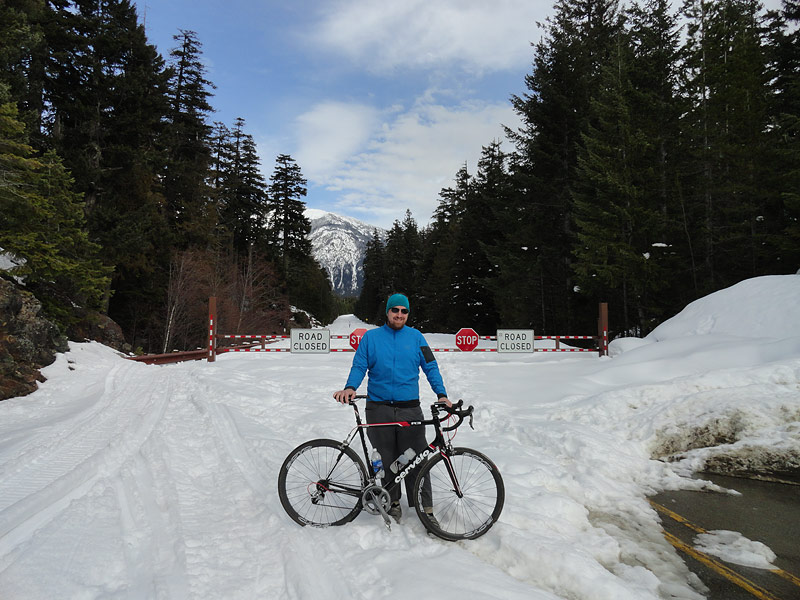

Same gate.I had always pictured myself skiing up from the closure above, although to be honest the scenery is better from Diablo, "better" being like trying to pick your favorite child because it's spectacular everywhere. It isn't the cost of plowing that closes the highway, it's avalanches. The avy potential gets pretty high not very far beyond this gate, and it was storming hard on Saturday, so I turned around here.
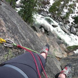
Here's an example, from a ride a couple years ago, of why I didn't want to continue.

They generally follow gullies, and you can't tell when they'll go off, but the weight of a lot of new snow causes a lot of stress and that's not a good time to be there.Few more bike pics from way back when.

It doesn't look very steep, but this was a fun descent.


https://connect.garmin.com/modern/activity/4453005043
If the Sierra are the "Range of Light," the North Cascades are the Range of Weather. And wilderness, but it's beautiful even from the road.
Diablo Lake is a wonderful place. The water is turquoise in the summer from glacial melt, but only when the sun hits it just right. There's a drive in camp here, a beach, and a couple miles away is a kayak camp.
Panos, then and now.
It wasn't partly sunny this time. But that's ok.
Pyramid and Colonial Peaks above. You can see the glacier that drains here, via Colonial Creek which gives its name to the car camp.
I've posted summer photos from Ross Lake, the dam is above. You can't see it because there's a waterfall of fog pouring down toward Diablo Lake.
Eight years ago, they used to close the road for the winter at the Ross Lake Trailhead. To save money from plow costs, they've moved the closure down to Colonial Creek.
Same gate.I had always pictured myself skiing up from the closure above, although to be honest the scenery is better from Diablo, "better" being like trying to pick your favorite child because it's spectacular everywhere. It isn't the cost of plowing that closes the highway, it's avalanches. The avy potential gets pretty high not very far beyond this gate, and it was storming hard on Saturday, so I turned around here.
Here's an example, from a ride a couple years ago, of why I didn't want to continue.
They generally follow gullies, and you can't tell when they'll go off, but the weight of a lot of new snow causes a lot of stress and that's not a good time to be there.Few more bike pics from way back when.
It doesn't look very steep, but this was a fun descent.
https://connect.garmin.com/modern/activity/4453005043
6
Replies
-
Thank you for the photos! Absolutely beautiful1
-
Awesome place and awesome job! We need to meet up and hit some trails this summer. I live in Rochester Washington and ride mountain bikes all over the state.1


This discussion has been closed.
Categories
- All Categories
- 1.4M Health, Wellness and Goals
- 396.7K Introduce Yourself
- 44.2K Getting Started
- 260.8K Health and Weight Loss
- 176.3K Food and Nutrition
- 47.6K Recipes
- 232.8K Fitness and Exercise
- 450 Sleep, Mindfulness and Overall Wellness
- 6.5K Goal: Maintaining Weight
- 8.7K Goal: Gaining Weight and Body Building
- 153.3K Motivation and Support
- 8.3K Challenges
- 1.3K Debate Club
- 96.5K Chit-Chat
- 2.6K Fun and Games
- 4.5K MyFitnessPal Information
- 16 News and Announcements
- 18 MyFitnessPal Academy
- 1.4K Feature Suggestions and Ideas
- 3.1K MyFitnessPal Tech Support Questions