Cucamonga Peak #9/18

cheriej2042
Posts: 241 Member
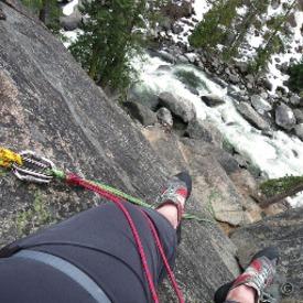
Have been hiking a lot but couldn’t find a good peak for my 18 peak challenge due to rain/snow. Cucamonga Peak is one of the highest in the San Gabriel mountains at 8,862 feet. It is named for the 19 th century Mexican land grant Rancho Cucamonga that was right below it.
I decided to attempt this and waited until we had some warm weather. This is an 11.4 mile out/back trail with 4,219 ft of elevation. The hike starts out along a creek and then climbs up to a saddle at 4 miles. Great views on the way up and at the saddle. Usually I see people here because 5 different trails branch off from there but no one there at the time.


I had to put micro spikes on after the saddle but didn’t hit any deep snow until about a mile from the summit. You get to a series of switchbacks and the snow gets about thigh deep. I was able to figure out the trail because some had left some deep post holes but I still had to keep looking at my AllTrails map to make sure I wasn’t going the wrong way.
Got to the summit and some clouds moved in dropping some pin size snow but it wasn’t much. Wish I had someone to take my picture but I had the trail to myself. I only saw a few people when I returned to the saddle. I guess everyone is waiting for the snow to melt.


I was going to attempt Ontario Peak but snow is still too deep so I’m going to try Mt Wilson next week.
I decided to attempt this and waited until we had some warm weather. This is an 11.4 mile out/back trail with 4,219 ft of elevation. The hike starts out along a creek and then climbs up to a saddle at 4 miles. Great views on the way up and at the saddle. Usually I see people here because 5 different trails branch off from there but no one there at the time.
I had to put micro spikes on after the saddle but didn’t hit any deep snow until about a mile from the summit. You get to a series of switchbacks and the snow gets about thigh deep. I was able to figure out the trail because some had left some deep post holes but I still had to keep looking at my AllTrails map to make sure I wasn’t going the wrong way.
Got to the summit and some clouds moved in dropping some pin size snow but it wasn’t much. Wish I had someone to take my picture but I had the trail to myself. I only saw a few people when I returned to the saddle. I guess everyone is waiting for the snow to melt.
I was going to attempt Ontario Peak but snow is still too deep so I’m going to try Mt Wilson next week.
8
Replies
-
Wow. Really beautiful. Well done on trudging through thigh-deep snow. Congrats on #9.
") 2
2 -
Badass! That's a lot of elevation gain, almost 1k per mile? Steep! But gorgeous! I love the pondo pines.
8,862' would qualify as a Bulger peak up here. If you're ever in the area, bring good shoes. 🙂1

This discussion has been closed.
Categories
- All Categories
- 1.4M Health, Wellness and Goals
- 396.9K Introduce Yourself
- 44.2K Getting Started
- 260.9K Health and Weight Loss
- 176.3K Food and Nutrition
- 47.6K Recipes
- 232.8K Fitness and Exercise
- 454 Sleep, Mindfulness and Overall Wellness
- 6.5K Goal: Maintaining Weight
- 8.7K Goal: Gaining Weight and Body Building
- 153.3K Motivation and Support
- 8.3K Challenges
- 1.3K Debate Club
- 96.5K Chit-Chat
- 2.6K Fun and Games
- 4.5K MyFitnessPal Information
- 16 News and Announcements
- 18 MyFitnessPal Academy
- 1.4K Feature Suggestions and Ideas
- 3.1K MyFitnessPal Tech Support Questions