This is what 1,700 calories looks like
Options
NorthCascades
Posts: 10,968 Member
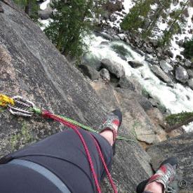
This is a summit I've been wanting to do for years, but never as a priority. It's a short and very, very steep hike, I usually prefer longer ones. Turns out there are side trails and I was able to spend as much time as I wanted in the Snoqualmie highlands. There was a lot more snow on the ground than I expected, much higher parts of the Cascades are melted out by this point in a typical year.


13
Replies
-
Stunning scenery!
1 -
Wonderful! What was the distance and elevation gained? I'm curious as I evaluate hikes based on average gradient. I can do a 900m climb over 10km, but I can't do the same over half the distance as I found out last summer
 1
1 -
That's so beautiful, NC.
It's been an exceptionally cool spring and summer here in the PNDub. Seems like all of Nature is behind by a month.") 1
1 -
Wonderful! What was the distance and elevation gained? I'm curious as I evaluate hikes based on average gradient. I can do a 900m climb over 10km, but I can't do the same over half the distance as I found out last summer
To the peak was 2,000 feet (610 meters) over 2.75 miles (4.4 km). Those two lakes that are visible from the summit added some more and I don't have the Garmin app up with the details but they were more level. This was very steep, my group of friends call it "rude" and I'm not sure if they mean whoever made the trail or what.1 -
I got "lost" for a moment. Walked right off the end of a switchback taking pictures of the sun filtering down through the old growth. There was a game trail that just sort of disappeared. Having maps in the watch made it easy to find the most convenient way back to the trail instead of going back up hill to it. I have satellite and topo maps in my phone, and a paper map in my backpack, but they're both in zipper pockets and the Fenix maps are good enough for this.0
-
NorthCascades wrote: »Wonderful! What was the distance and elevation gained? I'm curious as I evaluate hikes based on average gradient. I can do a 900m climb over 10km, but I can't do the same over half the distance as I found out last summer
To the peak was 2,000 feet (610 meters) over 2.75 miles (4.4 km). Those two lakes that are visible from the summit added some more and I don't have the Garmin app up with the details but they were more level. This was very steep, my group of friends call it "rude" and I'm not sure if they mean whoever made the trail or what.
Wow, I think I would have had seriously difficulties with that! Can I ask you something, because I always wanted to know: How difficult is such a walk up for you? Were you able to talk to someone or did you have to stop at regular intervals? Did your legs hurt?
(maybe stupid, but I have a medical condition that makes these kind of walks difficult. I want to know what's 'normal'. When I hike up 900m over 10km then I mange 50-250 steps before I need to stop briefly. 900m over 5km and I partially didn't even manage 10 steps. Yeah, I'm born with it, and it's finally under investigation)2 -
NorthCascades wrote: »Wonderful! What was the distance and elevation gained? I'm curious as I evaluate hikes based on average gradient. I can do a 900m climb over 10km, but I can't do the same over half the distance as I found out last summer
To the peak was 2,000 feet (610 meters) over 2.75 miles (4.4 km). Those two lakes that are visible from the summit added some more and I don't have the Garmin app up with the details but they were more level. This was very steep, my group of friends call it "rude" and I'm not sure if they mean whoever made the trail or what.
Wow, I think I would have had seriously difficulties with that! Can I ask you something, because I always wanted to know: How difficult is such a walk up for you? Were you able to talk to someone or did you have to stop at regular intervals? Did your legs hurt?
(maybe stupid, but I have a medical condition that makes these kind of walks difficult. I want to know what's 'normal'. When I hike up 900m over 10km then I mange 50-250 steps before I need to stop briefly. 900m over 5km and I partially didn't even manage 10 steps. Yeah, I'm born with it, and it's finally under investigation)
At times it was extremely difficult. I try to go at a slower but sustainable pace instead of stopping for breaks, but there were parts that were extremely steep and to maintain any forward motion I had to give it everything I had and was hugging and puffing, followed by a stop for water and rest.2 -
Gorgeous, as always!!!1


Categories
- All Categories
- 1.4M Health, Wellness and Goals
- 396.6K Introduce Yourself
- 44.2K Getting Started
- 260.8K Health and Weight Loss
- 176.3K Food and Nutrition
- 47.6K Recipes
- 232.8K Fitness and Exercise
- 449 Sleep, Mindfulness and Overall Wellness
- 6.5K Goal: Maintaining Weight
- 8.7K Goal: Gaining Weight and Body Building
- 153.3K Motivation and Support
- 8.3K Challenges
- 1.3K Debate Club
- 96.5K Chit-Chat
- 2.6K Fun and Games
- 4.5K MyFitnessPal Information
- 16 News and Announcements
- 18 MyFitnessPal Academy
- 1.4K Feature Suggestions and Ideas
- 3K MyFitnessPal Tech Support Questions