Running Lakeshore Path in Chicago
Options

sheddingmyfatsuit
Posts: 28 Member
Any Chicago folks here? I'm going to be in Chicago in May and some of my weight loss "bucket list" to-do's include running in a few well known spots around the country. So of course I need to do the Lakeshore path in Chicago while I am there.
Lookiing for suggestions as to the best/most scenic sections of that path to run. I'm staying at the Hyatt Regency on Wacker but am willing to travel from there a bit if it means finding the "perfect" section of the trail to run.
Thanks!
Lookiing for suggestions as to the best/most scenic sections of that path to run. I'm staying at the Hyatt Regency on Wacker but am willing to travel from there a bit if it means finding the "perfect" section of the trail to run.
Thanks!
0
Replies
-
bump.
No Chicagoan's that want to give their $0.02?0 -
Here's some information that might be helpful:
http://www.chicagobikes.org/pdf/lakefront_trail061608.pdf
But, I thought some pics/suggestions might be good as well.
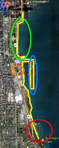
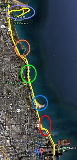
So, from where you're staying, here's how you get to the lake front path (right click on this pic and select "Open in new window" or "Open in new tab" as the pic is too big to fit on the forum page completely):
Go East (toward the lake) to Columbus Drive to get on the riverwalk and take that until you cross under US 41/Lakeshore Drive. Once you pass underneath Lakeshore Drive, you'll see the lake front path going north over the Chicago river or south towards Grant Park. You can tell it's the lake shore path because, unlike a side walk, it has yellow and white lane lines painted on it.
Now, you have to decide what you want to see and where you'd like to go...but you only have two choices: North or South.
If you go South:
Green Circle: Chicago's Grant Park offering great views of the park, the lake, and downtown Chicago (aka: the Loop).
Orange Circle: Soldier Field (home of the Chicago Bears). The Field Museum and Shed Aquarium is right there as well.
Blue Circle: Chicago's Northerly Isle. This used to be a small plane airport but is now a nature conservatory. The Adler Planetarium is at the far north end. Between Northerly Isle and Soldier Field is Burnahm Harbor, home to some of the largest (and most expensive) boats in Chicago.
Red Circle: Chicago's newest harbor: 31st Street Harbor. Between Soldier field and the harbor are grass fields, a skate park and good views of the southern tip of Lake Michigan. The real benefit to running this far down comes when you turn around and start heading North again. From down here, downtown Chicago appears to be jetting out into Lake Michigan.
If you go North:
Red Circle: Oak Street Beach, right by the "S-Turn" on Lake Michigan. When it's hot (which it probably won't be in May) this is a great place to people watch.
Blue Circle: North Street Beach
Green Circle: Diversey Harbor
Orange Circle: Belmont Harbor
Purple Circle: Montrose Harbor. On the east end of Montrose harbor is another nature conservatory. You can continue farther north, but I recommend heading out to the far Southeast end of the Montrose harbor breakwall to get a fantastic view of downtown Chicago & the lake.
Hope that helps! Enjoy your time in Chicago!0 -
I will be biking this path sometime in May when the weather gets nicer.0
-
Thansk, dsendre, for the info. Very helpful!0
-
I would add that the path can become VERY crowded later in the day, so try to get out early in the AM. That doesn't guarantee anything, but it improves your chances of not getting run over by a Le Tour de France wannabe or having to run around people walking 5 abreast.0
This discussion has been closed.
Categories
- All Categories
- 1.4M Health, Wellness and Goals
- 396.9K Introduce Yourself
- 44.2K Getting Started
- 260.9K Health and Weight Loss
- 176.3K Food and Nutrition
- 47.6K Recipes
- 232.8K Fitness and Exercise
- 452 Sleep, Mindfulness and Overall Wellness
- 6.5K Goal: Maintaining Weight
- 8.7K Goal: Gaining Weight and Body Building
- 153.3K Motivation and Support
- 8.3K Challenges
- 1.3K Debate Club
- 96.5K Chit-Chat
- 2.6K Fun and Games
- 4.5K MyFitnessPal Information
- 16 News and Announcements
- 18 MyFitnessPal Academy
- 1.4K Feature Suggestions and Ideas
- 3.1K MyFitnessPal Tech Support Questions


