GPS / Science-y Question

Slainte831
Posts: 125 Member
How come, according to my GPS, if I start or end my walk or run at the same place, my ascent and descent numbers aren't the same?
I drive to a dirt road when I go running, so I can take my dog with me and let her run. So I run, turn around, and run back to my car. Yet my ascent and descent numbers are never equal (today, for instance, there is a 45’ difference between the numbers). Any ideas why?
I drive to a dirt road when I go running, so I can take my dog with me and let her run. So I run, turn around, and run back to my car. Yet my ascent and descent numbers are never equal (today, for instance, there is a 45’ difference between the numbers). Any ideas why?
0
Replies
-
Speed I would guess.
A.C.E. Certified Personal and Group Fitness Trainer
IDEA Fitness member
Kickboxing Certified Instructor
Been in fitness for 30 years and have studied kinesiology and nutrition 0
0 -
How would speed affect elevation? (I'm not questioning you -- just really curious).0
-
Not sure exactly how a GPS works with altitude, but moving over a distance slower would indicate less exertion if the terrain was considered flat, whereas if moving over the same terrain faster would indicate more exertion. Again I don't know if GPS accounts for that. If it does and your decent numbers are less, then less energy is expended going down than up. Which makes total sense.
A.C.E. Certified Personal and Group Fitness Trainer
IDEA Fitness member
Kickboxing Certified Instructor
Been in fitness for 30 years and have studied kinesiology and nutrition 0 -
It's your altimeter that accounts for elevation gain / loss and not your GPS. It's probably just within the error tolerance of your equipment.0
-
I have read that GPS is not very accurate for altitude. ±45 feet may be about the best you can hope for. Or if the device you’re using measures air pressure to estimate your altitude, it could change by hundreds of feet if you stand in the same spot while the weather changes.0
-
GPS has pretty awesome vertical accuracy - about +/- 7m typically (horizontal accuracy is typically +/- 5m). The problem is that the horizontal error bars are spread across a much bigger number so it looks more accurate. If you were to, say, climb Everest, the vertical error would likewise disappear into the noise.
0 -
If your GPS has a barometric altimeter, it's most likely due to changing atmospheric conditions. But most running GPS's don't have one. They use GPS data to estimate elevation changes, and that's pretty unreliable. If you're using a Garmin unit, you can enable elevation correction on the Garmin Connect website. Elevation correction will match your course points to Garmin's elevation database and use that instead of the GPS elevation. However, it can be incorrect if the elevation data are bad. Last week I went running along a fjord in Iceland. The uncorrected data indicated that I had gained and lost about 200 feet, while the "corrected" data indicated over 2,000 feet of climbing in an 8-mile run!0
-
If your GPS has a barometric altimeter, it's most likely due to changing atmospheric conditions. But most running GPS's don't have one. They use GPS data to estimate elevation changes, and that's pretty unreliable. If you're using a Garmin unit, you can enable elevation correction on the Garmin Connect website. Elevation correction will match your course points to Garmin's elevation database and use that instead of the GPS elevation. However, it can be incorrect if the elevation data are bad. Last week I went running along a fjord in Iceland. The uncorrected data indicated that I had gained and lost about 200 feet, while the "corrected" data indicated over 2,000 feet of climbing in an 8-mile run!
That's an average grade of nearly 5%...for 8 miles...are you confident that's accurate? Because that would be a Category 1 climb in the Tour de France.
(Not questioning *you* - there is just a lot of poor elevation data in maps, especially in lightly populated areas.)
0 -
Slainte831 wrote: »How come, according to my GPS, if I start or end my walk or run at the same place, my ascent and descent numbers aren't the same?
Any GPS unit has a pool of error, the size of that pool will depend on the quality of the device, how sensitive the antenna is, and how many channels it can receive on.
At any point in time a point on the earths surface should have between 9 and 12 spacecraft visible, as elevations change that could be fewer than 9 as hills, buildings etc can obscure line of sight. Vegetation will also absorb soe of the signal, so may reduce the number of visible spacecraft as well.
With 4-6 spacecraft you'll get a pretty good fix on the theoretical surface of the earth. To get elevation you need more to be visible. It can help to have a barometric altimeter to corroborate the GPS fx, but that's generally only on higher end devices.
If you're using a mobile phone, then you're probably not getting more than 6 channels reliably.
0 -
Interesting! Thanks, everyone!
PS, running in a fjord in Iceland sounds like paradise!! Were you visiting there or is that your home, @bwogilvie ?0 -
That's an average grade of nearly 5%...for 8 miles...are you confident that's accurate? Because that would be a Category 1 climb in the Tour de France.
(Not questioning *you* - there is just a lot of poor elevation data in maps, especially in lightly populated areas.)
@Mr_Knight: That was my point, which is why I put quotation marks around "corrected." My run was pretty flat, with a couple of moderate hills. The uncorrected 200 feet was pretty close. I don't think the elevation data were incorrect in themselves—I was in a fjord, with steep slopes rising from the sea—but that whichever mapping service Garmin uses for its elevation data had the road crossing contour lines instead of following them.0 -
Slainte831 wrote: »PS, running in a fjord in Iceland sounds like paradise!! Were you visiting there or is that your home, @bwogilvie ?
Unfortunately I was only there on vacation, @Slainte831. I imagine it would be pretty grim in the winter, though!0 -
Speed I would guess.
A.C.E. Certified Personal and Group Fitness Trainer
IDEA Fitness member
Kickboxing Certified Instructor
Been in fitness for 30 years and have studied kinesiology and nutrition
That's not really too far from the truth. I wear the same watch running and hiking and I've noticed that the altitude is more accurate when you're moving faster. If you stand still it can jump around 5 - 15 feet but when you're moving it keeps a fairly accurate description of where you're at. It's as if the device prefers change to get more of an idea on your altitude. You need a pressure sensing altimeter to get a better gauge of your altitude.
I was wearing my Garmin Forerunner 220 on a recent hike up a mountain that's 14,158 ft tall. I have pictures of me on the summit, and yet the max elevation my GPS watch recorded was 14,030 ft. That's a good bit off. As a result of this finding I just purchased one of these for hiking.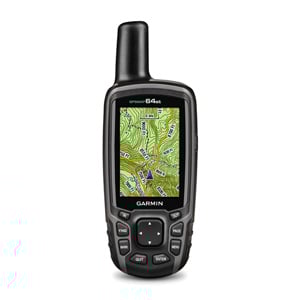
It's the Garmin GPSMap 64st and the altitude correction is fantastic. You can't get this close with just a watch on your arm. You really do need the antenna this big if you're going to be precise. For running the Forerunner is close enough to show that you climbed a hill or had a downhill trend but if you want to be specific to the point of knowing you're at a specific altitude you need a better instrument.
0 -
This content has been removed.
-
That's an average grade of nearly 5%...for 8 miles...are you confident that's accurate? Because that would be a Category 1 climb in the Tour de France.
(Not questioning *you* - there is just a lot of poor elevation data in maps, especially in lightly populated areas.)
@Mr_Knight: That was my point, which is why I put quotation marks around "corrected." My run was pretty flat, with a couple of moderate hills. The uncorrected 200 feet was pretty close. I don't think the elevation data were incorrect in themselves—I was in a fjord, with steep slopes rising from the sea—but that whichever mapping service Garmin uses for its elevation data had the road crossing contour lines instead of following them.
Gotcha! I've had that happen on trail runs, where data is sparse. It's like the map makes a guess by averaging out the elevation of the nearest roads, but when that doesn't work, it *really* doesn't work!
0 -
This is fascinating. Thanks everyone!0
-
MeanderingMammal wrote: »Slainte831 wrote: »How come, according to my GPS, if I start or end my walk or run at the same place, my ascent and descent numbers aren't the same?
Any GPS unit has a pool of error, the size of that pool will depend on the quality of the device, how sensitive the antenna is, and how many channels it can receive on.
At any point in time a point on the earths surface should have between 9 and 12 spacecraft visible, as elevations change that could be fewer than 9 as hills, buildings etc can obscure line of sight. Vegetation will also absorb soe of the signal, so may reduce the number of visible spacecraft as well.
With 4-6 spacecraft you'll get a pretty good fix on the theoretical surface of the earth. To get elevation you need more to be visible. It can help to have a barometric altimeter to corroborate the GPS fx, but that's generally only on higher end devices.
If you're using a mobile phone, then you're probably not getting more than 6 channels reliably.
This.
I got into geocaching pretty heavy when the military first opened the GPS satellites (Those satellites are at least 30 years old BTW) to civilian use. The early GPS units on a good day had a margin of error of 10 square feet. Which means what you were looking for could be in a circle of 20 feet. If trees or buildings were around you could count on doubling that margin of error. I'm not sure most GPS users understand how inexact GPS units can be.
0 -
iplayoutside19 wrote: »Those satellites are at least 30 years old
The constellation is refreshed on a routine basis, none of the original space vehicles remain in use, at least GPS. I'm less sure of the GLONASS constellation.
0


This discussion has been closed.
Categories
- All Categories
- 1.4M Health, Wellness and Goals
- 398.4K Introduce Yourself
- 44.7K Getting Started
- 261K Health and Weight Loss
- 176.4K Food and Nutrition
- 47.7K Recipes
- 233K Fitness and Exercise
- 462 Sleep, Mindfulness and Overall Wellness
- 6.5K Goal: Maintaining Weight
- 8.7K Goal: Gaining Weight and Body Building
- 153.5K Motivation and Support
- 8.4K Challenges
- 1.4K Debate Club
- 96.5K Chit-Chat
- 2.6K Fun and Games
- 4.8K MyFitnessPal Information
- 17 News and Announcements
- 21 MyFitnessPal Academy
- 1.5K Feature Suggestions and Ideas
- 3.2K MyFitnessPal Tech Support Questions