My Garmin did me right today + I took my nice road bike on single track today. (pics)
Options

NorthCascades
Posts: 10,968 Member
I was looking forward to taking my bike to Easton and riding some roads I've only ever seen from skis. But there's a fire burning nearby and the smoke in the air is atrocious. I turned around, parked at a lower altitude (river valley) town where I couldn't see the air I was breathing.
I asked my Garmin (Fenix 5X) for a ~30 mile round trip route, and relied on it (followed it blindly). I don't know the area well enough to find a good route, I would have picked a bad one from the map. Instead, the watch strung a route together for me on roads, rail-to-trails, even a bit of singletrack, with a fast and twisty descent, but it avoided highways. It was a tough, but a great route.
I did 27.5 miles today, I think 16 were unpaved, and gained 1,476 feet, in 2 hours. Only got me 918 calories.
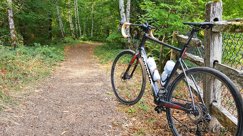
This was the most picturesque section of trail, but not the roughest! By the time I was dodging rocks and roots, I was already committed, I'd have to turn around and retrace 15 miles to get back to my car. I had no idea where I was. That added to the sense of adventure.


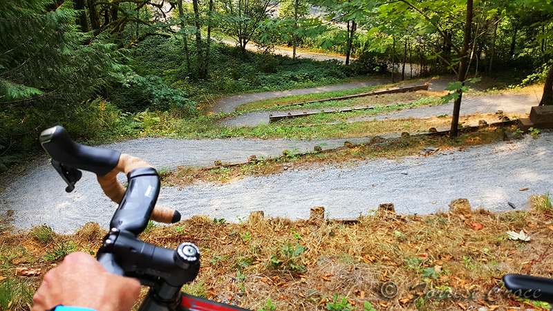
I had to get off and walk down this part. For one thing, a sign informed me it's the law; for another, the gravel was too deep for me on 28s and the switchbacks too small.

My route kept taking me on and off the Snoqualmie Valley Trail. Here's what it looked like.


https://connect.garmin.com/modern/activity/1958879651
https://www.relive.cc/view/1168777636
I asked my Garmin (Fenix 5X) for a ~30 mile round trip route, and relied on it (followed it blindly). I don't know the area well enough to find a good route, I would have picked a bad one from the map. Instead, the watch strung a route together for me on roads, rail-to-trails, even a bit of singletrack, with a fast and twisty descent, but it avoided highways. It was a tough, but a great route.
I did 27.5 miles today, I think 16 were unpaved, and gained 1,476 feet, in 2 hours. Only got me 918 calories.
This was the most picturesque section of trail, but not the roughest! By the time I was dodging rocks and roots, I was already committed, I'd have to turn around and retrace 15 miles to get back to my car. I had no idea where I was. That added to the sense of adventure.


I had to get off and walk down this part. For one thing, a sign informed me it's the law; for another, the gravel was too deep for me on 28s and the switchbacks too small.

My route kept taking me on and off the Snoqualmie Valley Trail. Here's what it looked like.


https://connect.garmin.com/modern/activity/1958879651
https://www.relive.cc/view/1168777636
10
Replies
-
I'm curious how this works from a following the watch perspective. How does it give you the directions? I'm not able to financially get the Fenix but have wondered! Would be so handy for walking/hiking, especially as I got massively lost last time.1
-
VintageFeline wrote: »I'm curious how this works from a following the watch perspective. How does it give you the directions? I'm not able to financially get the Fenix but have wondered! Would be so handy for walking/hiking, especially as I got massively lost last time.
Im curious too.....how does it tell you where to go?1 -
These pictures are amazing! Sounds like you had a brilliant time
 1
1 -
VintageFeline wrote: »I'm curious how this works from a following the watch perspective. How does it give you the directions? I'm not able to financially get the Fenix but have wondered! Would be so handy for walking/hiking, especially as I got massively lost last time.
Not sure how it works for sure as my watch doesn't download the routes, but from what I have seen from the software, you create a route in your laptop/phone and then it downloads to the device.
Good blog on it here https://hikingguy.com/how-to-hike/creating-a-hike-garmin-gps/1 -
I actually went and Googled. Because I'm good like that. You do as above and plan a route, I think. Anyway, that part I'm not so curious about it was more how you got the directions. It's like the arrow you get when using Google maps walking but literally just the arrow and some text. So pretty simple and easy to see. Arrow points left you go left until it points in another direction etc etc.
1 -
VintageFeline wrote: »I actually went and Googled. Because I'm good like that. You do as above and plan a route, I think. Anyway, that part I'm not so curious about it was more how you got the directions. It's like the arrow you get when using Google maps walking but literally just the arrow and some text. So pretty simple and easy to see. Arrow points left you go left until it points in another direction etc etc.
I use the Garmin Connect for planning my routes for hiking so I can get an idea of how much time at my normal hiking pace and the distance is. If I upgrade at some point might look for one with that feature because it does look pretty handy.1 -
VintageFeline wrote: »I actually went and Googled. Because I'm good like that. You do as above and plan a route, I think. Anyway, that part I'm not so curious about it was more how you got the directions. It's like the arrow you get when using Google maps walking but literally just the arrow and some text. So pretty simple and easy to see. Arrow points left you go left until it points in another direction etc etc.
The watch vibrates, and says "Left on Main" with an arrow pointing left. First as you approach the turn, then again when you get to it.
The really nice thing was having it generate a route for me to follow. I don't know North Bend terribly well, didn't realize the trails were there to connect sleepy roads.1 -
Now that is nifty.1
-
Great pics, nice ride!1
-
Nice. I love having nav on my Bolt. It's opened up a whole new aspect of riding for me.1
-
I had no idea that there was a Garmin model that did that, I will now have to get it!1
-
Nice!1
-
I had no idea that there was a Garmin model that did that, I will now have to get it!
Actually they've had that feature for a few years. I know the Edge 1000 had it.
I used to have an 800 which didn't have that feature, but had maps and navigation. I would ride for a while, then tell it to navigate me back to the start, and sorry of force it to make a loop. Downside was every now and then I'd head down a dead end road without realizing it, so there wasn't a round trip.0 -
NorthCascades wrote: »
Actually they've had that feature for a few years. I know the Edge 1000 had it.
I used to have an 800 which didn't have that feature, but had maps and navigation. I would ride for a while, then tell it to navigate me back to the start, and sorry of force it to make a loop. Downside was every now and then I'd head down a dead end road without realizing it, so there wasn't a round trip.
I've got the vivoactive HR which doesn't have the feature.
Looked into the Fenix more and it does KOM/QOM off Strava as well, that's awesome!1 -
Ha! Lake Alice Road. I know it from the section that goes up.
 . I also know that the "official" bike path is I-90. Trust me, you chose wisely. 1
This discussion has been closed.
Categories
- All Categories
- 1.4M Health, Wellness and Goals
- 396.8K Introduce Yourself
- 44.2K Getting Started
- 260.9K Health and Weight Loss
- 176.3K Food and Nutrition
- 47.6K Recipes
- 232.8K Fitness and Exercise
- 451 Sleep, Mindfulness and Overall Wellness
- 6.5K Goal: Maintaining Weight
- 8.7K Goal: Gaining Weight and Body Building
- 153.3K Motivation and Support
- 8.3K Challenges
- 1.3K Debate Club
- 96.5K Chit-Chat
- 2.6K Fun and Games
- 4.5K MyFitnessPal Information
- 16 News and Announcements
- 18 MyFitnessPal Academy
- 1.4K Feature Suggestions and Ideas
- 3.1K MyFitnessPal Tech Support Questions


