Space
Replies
-
M82: Galaxy with a Supergalactic Wind

Why is the Cigar Galaxy billowing red smoke? M82, as this starburst galaxy is also known, was stirred up by a recent pass near large spiral galaxy M81. This doesn't fully explain the source of the red-glowing outwardly expanding gas and dust, however.
Evidence indicates that this gas and dust is being driven out by the combined emerging particle winds of many stars, together creating a galactic superwind. The dust particles are thought to originate in M82's interstellar medium and are actually similar in size to particles in cigar smoke.
The featured photographic mosaic highlights a specific color of red light strongly emitted by ionized hydrogen gas, showing detailed filaments of this gas and dust. The filaments extend for over 10,000 light years.
The 12-million light-year distant Cigar Galaxy is the brightest galaxy in the sky in infrared light, and can be seen in visible light with a small telescope towards the constellation of the Great Bear (Ursa Major).2 -
Zodiacal Road

What's that strange light down the road? Dust orbiting the Sun. At certain times of the year, a band of sun-reflecting dust from the inner Solar System appears prominently just after sunset -- or just before sunrise -- and is called zodiacal light.
Although the origin of this dust is still being researched, a leading hypothesis holds that zodiacal dust originates mostly from faint Jupiter-family comets and slowly spirals into the Sun. Recent analysis of dust emitted by Comet 67P, visited by ESA's robotic Rosetta spacecraft, bolster this hypothesis.
Pictured when climbing a road up to Teide National Park in the Canary Islands of Spain, a bright triangle of zodiacal light appeared in the distance soon after sunset. Captured on June 21, the scene includes bright Regulus, alpha star of Leo, standing above center toward the left.
The Beehive Star Cluster (M44) can be spotted below center, closer to the horizon and also immersed in the zodiacal glow.3 -
This content has been removed.
-
JustReadTheInstructions wrote: »I take some dec ones with my telescope
Is that a scientific term about space?0 -
Cygnus Skyscape

In brush strokes of interstellar dust and glowing hydrogen gas, this beautiful skyscape is painted across the plane of our Milky Way Galaxy near the northern end of the Great Rift and the constellation Cygnus the Swan. Composed with three different telescopes and about 90 hours of image data the widefield mosaic spans an impressive 24 degrees across the sky. Alpha star of Cygnus, bright, hot, supergiant Deneb lies near top center.
Crowded with stars and luminous gas clouds Cygnus is also home to the dark, obscuring Northern Coal Sack Nebula, extending from Deneb toward the center of the view. The reddish glow of star forming regions NGC 7000, the North America Nebula and IC 5070, the Pelican Nebula, are just left of Deneb. The Veil Nebula is a standout below and left of center.
A supernova remnant, the Veil is some 1,400 light years away, but many other nebulae and star clusters are identifiable throughout the cosmic scene. Of course, Deneb itself is also known to northern hemisphere skygazers for its place in two asterisms -- marking the top of the Northern Cross and a vertex of the Summer Triangle.2 -

2 -
This content has been removed.
-
This content has been removed.
-
This content has been removed.
-
Central IC 1805

Cosmic clouds seem to form fantastic shapes in the central regions of emission nebula IC 1805. Of course, the clouds are sculpted by stellar winds and radiation from massive hot stars in the nebula's newborn star cluster (aka Melotte 15).
About 1.5 million years young, the cluster stars appear in this colorful skyscape, along with dark dust clouds silhouetted against glowing atomic gas. A composite of narrow band telescopic images, the view spans about 15 light-years and shows emission from hydrogen in green, sulfur in red, and oxygen in blue hues.
Wider field images reveal that IC 1805's simpler, overall outline suggests its popular name - The Heart Nebula. IC 1805 is located about 7,500 light years away toward the constellation Cassiopeia.1 -
Hubble Snaps a Galactic Potpourri of Particles

Every now and then, the NASA/ESA Hubble Space Telescope glimpses a common object — say, a spiral galaxy — in an interesting or unusual way. A sharply angled perspective, such as the one shown in this Hubble image, can make it seem as if we, the viewers, are craning our necks to see over a barrier into the galaxy's bright center.
In the case of NGC 3169, this barrier is the thick dust embedded within the galaxy's spiral arms. Cosmic dust comprises a potpourri of particles, including water ice, hydrocarbons, silicates and other solid material. It has many origins and sources, from the leftovers of star and planet formation to molecules modified over millions of years by interactions with starlight.
NGC 3169 is located about 70 million light-years away in the constellation of Sextans (the Sextant). It is part of the Leo I Group of galaxies, which, like the Local Group that houses our home galaxy, the Milky Way, is part of a larger galactic congregation known as the Virgo Supercluster.1 -
Star Forming Region NGC 3582 without Stars

What's happening in the Statue of Liberty nebula? Bright stars and interesting molecules are forming and being liberated. The complex nebula resides in the star forming region called RCW 57, and besides the iconic monument, to some looks like a flying superhero or a weeping angel.
By digitally removing the stars, this image showcases dense knots of dark interstellar dust, fields of glowing hydrogen gas ionized by these stars, and great loops of gas expelled by dying stars. A detailed study of NGC 3576, also known as NGC 3582 and NGC 3584, uncovered at least 33 massive stars in the end stages of formation, and the clear presence of the complex carbon molecules known as polycyclic aromatic hydrocarbons (PAHs).
PAHs are thought to be created in the cooling gas of star forming regions, and their development in the Sun's formation nebula five billion years ago may have been an important step in the development of life on Earth.2 -

2 -
IC 1795: The Fishhead Nebula

To some, this nebula looks like the head of a fish. However, this colorful cosmic portrait really features glowing gas and obscuring dust clouds in IC 1795, a star forming region in the northern constellation Cassiopeia. The nebula's colors were created by adopting the Hubble color palette for mapping narrow emission from oxygen, hydrogen, and sulfur atoms to blue, green and red colors, and further blending the data with images of the region recorded through broadband filters.
Not far on the sky from the famous Double Star Cluster in Perseus, IC 1795 is itself located next to IC 1805, the Heart Nebula, as part of a complex of star forming regions that lie at the edge of a large molecular cloud. Located just over 6,000 light-years away, the larger star forming complex sprawls along the Perseus spiral arm of our Milky Way Galaxy. At that distance, this picture would span about 70 light-years across IC 1795.2 -
Elements in the Aftermath

Massive stars spend their brief lives furiously burning nuclear fuel. Through fusion at extreme temperatures and densities surrounding the stellar core, nuclei of light elements ike Hydrogen and Helium are combined to heavier elements like Carbon, Oxygen, etc. in a progression which ends with Iron. So a supernova explosion, a massive star's inevitable and spectacular demise, blasts back into space debris enriched in heavier elements to be incorporated into other stars and planets and people).
This detailed false-color x-ray image from the orbiting Chandra Observatory shows such a hot, expanding stellar debris cloud about 36 light-years across. Cataloged as G292.0+1.8, this young supernova remnant is about 20,000 light-years distant toward the southern constellation Centaurus. Light from the inital supernova explosion reached Earth an estimated 1,600 years ago. Bluish colors highlight filaments of the mulitmillion degree gas which are exceptionally rich in Oxygen, Neon, and Magnesium.
This enriching supernova also produced a pulsar in its aftermath, a rotating neutron star remnant of the collapsed stellar core. The stunning image was released as part of the 20th anniversary celebration of the Chandra X-ray Observatory.2 -
Rumors of a Dark Universe

Twenty-one years ago results were first presented indicating that most of the energy in our universe is not in stars or galaxies but is tied to space itself. In the language of cosmologists, a large cosmological constant -- dark energy -- was directly implied by new distant supernova observations.
Suggestions of a cosmological constant were not new -- they have existed since the advent of modern relativistic cosmology. Such claims were not usually popular with astronomers, though, because dark energy was so unlike known universe components, because dark energy's abundance appeared limited by other observations, and because less-strange cosmologies without a significant amount of dark energy had previously done well in explaining the data.
What was exceptional here was the seemingly direct and reliable method of the observations and the good reputations of the scientists conducting the investigations. Over the two decades, independent teams of astronomers have continued to accumulate data that appears to confirm the existence of dark energy and the unsettling result of a presently accelerating universe. In 2011, the team leaders were awarded the Nobel Prize in Physics for their work.
The featured picture of a supernova that occurred in 1994 on the outskirts of a spiral galaxy was taken by one of these collaborations.1 -
This content has been removed.
-

2 -
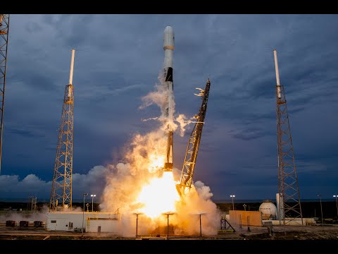
JustReadTheInstructions wrote: »There's a Falcon 9 launch tonight at 6:53pm EDT from Florida. Satellite will deploy approx 31 minutes after liftoff.
 https://www.youtube.com/watch?v=fZh82-WcCuo&feature=youtu.be
I can't believe I missed it again.... what's wrong with me...0 -
Long Lovejoy and Little Dumbbell

Buffeted by the solar wind, Comet Lovejoy's crooked ion tail stretches over 3 degrees across this telescopic field of view, recorded on February 20, 2015. The starry background includes awesome bluish star Phi Persei below, and pretty planetary nebula M76 just above Lovejoy's long tail. Also known as the Little Dumbbell Nebula, after its brighter cousin M27 the Dumbbell Nebula, M76 is only a Full Moon's width away from the comet's greenish coma.
Still shining in northern hemisphere skies, this Comet Lovejoy (C/2014 Q2) is outbound from the inner solar system some 10 light-minutes or 190 million kilometers from Earth. But the Little Dumbbell actually lies over 3 thousand light-years away. Now sweeping steadily north toward the constellation Cassiopeia Comet Lovejoy is fading more slowly than predicted and is still a good target for small telescopes.1 -
NGC 7635: The Bubble Nebula

Blown by the wind from a massive star, this interstellar apparition has a surprisingly familiar shape. Cataloged as NGC 7635, it is also known simply as The Bubble Nebula. Although it looks delicate, the 7 light-year diameter bubble offers evidence of violent processes at work. Above and left of the Bubble's center is a hot, O-type star, several hundred thousand times more luminous and around 45 times more massive than the Sun.
A fierce stellar wind and intense radiation from that star has blasted out the structure of glowing gas against denser material in a surrounding molecular cloud. The intriguing Bubble Nebula and associated cloud complex lie a mere 7,100 light-years away toward the boastful constellation Cassiopeia.
This sharp, tantalizing view of the cosmic bubble is a composite of Hubble Space Telescope image data from 2016, released to celebrate the 26th anniversary of Hubble's launch.1 -
This content has been removed.
-
Hubble Spots Jupiter’s Great Red Spot

3 -
mattig89ch wrote: »Hubble Spots Jupiter’s Great Red Spot
Did you know the Red Spot is disappearing?0 -
Atlas at Dawn

This single, 251-second long exposure follows the early flight of an Atlas V rocket on August 8, streaking eastward toward the dawn from Cape Canaveral Air Force Station, planet Earth. The launch of the United Launch Alliance rocket was at 6:13am local time.
Sunrise was not until 6:48am, but the rocket's downrange plume at altitude is brightly lit by the Sun still just below the eastern horizon. Waters of the Indian River Lagoon in Palm Shores, Forida reflect subtle colors and warming glow of the otherwise calm, predawn sky.
The mighty Atlas rocket carried a military communications satellite into Earth orbit. Of course, this weekend the streaks you see in clear skies before the dawn could be Perseid Meteors.
1 -
Supernova Factory NGC 2770

The stellar explosions known as supernovae are among the most powerful events in the universe. Triggered by the collapsing core of a massive star or the nuclear demise of a white dwarf, supernovae occur in average spiral galaxies only about once every century. But the remarkable spiral galaxy NGC 2770 has lately produced more than its fair share.
Two still bright supernovae and the location of a third, originally spotted in 1999 but now faded from view, are indicated in this image of the edge-on spiral. All three supernovae are now thought to be of the core-collapse variety, but the most recent of the trio, SN2008D, was first detected by the Swift satellite at more extreme energies as an X-ray flash (XRF) or possibly a low-energy version of a gamma-ray burst on January 9, 2008.
Located a mere 90 million light-years away in the northern constellation Lynx, NGC 2770 is now the closest galaxy known to host such a powerful supernova event.1 -
Hubble Catches 2 Galaxies at Play

2 -
mattig89ch wrote: »Hubble Spots Jupiter’s Great Red Spot
Did you know the Red Spot is disappearing?
No, I actually didn't know that0 -
This content has been removed.
-
JustReadTheInstructions wrote: »Two things:
1. Go to the NASA website to have your name sent on a chip with the new Mars Rover in 2020 🎫 https://go.nasa.gov/Mars2020pass
2. Get your eyeballs outside and check out the Perseid Meteor Shower 💫
1


This discussion has been closed.
Categories
- All Categories
- 1.4M Health, Wellness and Goals
- 398.2K Introduce Yourself
- 44.7K Getting Started
- 261K Health and Weight Loss
- 176.4K Food and Nutrition
- 47.7K Recipes
- 233K Fitness and Exercise
- 463 Sleep, Mindfulness and Overall Wellness
- 6.5K Goal: Maintaining Weight
- 8.7K Goal: Gaining Weight and Body Building
- 153.5K Motivation and Support
- 8.4K Challenges
- 1.4K Debate Club
- 96.5K Chit-Chat
- 2.6K Fun and Games
- 4.8K MyFitnessPal Information
- 13 News and Announcements
- 21 MyFitnessPal Academy
- 1.6K Feature Suggestions and Ideas
- 3.2K MyFitnessPal Tech Support Questions