Space
Replies
-
This content has been removed.
-
The show I watch was called Ancient Aliens: History Channel
Mars with humans . https://youtu.be/k-1yFuq2VeA 1
 -
This content has been removed.
-
JustReadTheInstructions wrote: »If you enjoyed that you might like an app game called TerraGenesis. You can terraform the moon, Mars, and other planets by figuring out how to change and balance pressure, CO2, create an atmosphere, build habitats etc. It's fun.
Sounds cool . Will check it out thanks.0 -

Canadian-led team tests general theory of relativity on a rare pulsar with 2 white dwarf companions.
Einstein's gravity theory passes extreme test on zombie star.
So finds the most extreme test yet of a key principle of gravity from Einstein's general theory of relativity called the strong equivalence principle, which states that all objects fall the same way in the same gravity.
Some other theories of gravity had suggested that the principle might not apply in cases with extreme gravity, like neutron stars.
Such "zombie stars" are sometimes left behind after a massive star explodes in a supernova.
The material collapses back into a core so dense that a teaspoon of it would weigh as much as Mount Everest.
But a study led by Canadian astronomer Anne Archibald,
took really precise measurements of a neutron star called a pulsar "falling" toward another star.
The researchers compared that to measurements of a much lighter white dwarf star (with just a fifth the mass of the sun) falling toward the same star, and found no measurable difference in their response to the star's gravity.
What made the test possible was the discovery of a rare and unique trio of stars by Stairs and some colleagues in 2012 — a special kind of neutron star orbiting in a triple star system.
The neutron star observed in this study is a millisecond pulsar, a neutron star that spins extremely quickly — 366 times per second, in this case. Like a lighthouse that emits a blinking beam of light as it turns, the pulsar emits a beam of radio waves that hits the Earth as a series of pulses. That speed of pulsar is rare — most rotate at less than a tenth of that speed.
But what's even rarer is a pulsar orbiting with two other stars — it and a smaller white dwarf circle each other, as a slightly larger white dwarf orbits them both. While active, "living" stars are often found as trios, neighbouring stars typically don't survive the massive explosion that generates a neutron star.
"For a triple system to survive a supernova that forms a pulsar is really remarkable," Archibald said.
Right away, Stairs said, researchers realized this system, called PSR J0337+1715 and located about 4,200 light-years away in the constellation Taurus, could be used for a unique test of gravity.0 -
Spiral Galaxy NGC 1232

Galaxies are fascinating not only for what is visible, but for what is invisible. Grand spiral galaxy NGC 1232, captured in detail by one of the new Very Large Telescopes, is a good example. The visible is dominated by millions of bright stars and dark dust, caught up in a gravitational swirl of spiral arms rotating about the center. Open clusters containing bright blue stars can be seen sprinkled along these spiral arms, while dark lanes of dense interstellar dust can be seen sprinkled between them.
Less visible, but detectable, are billions of dim normal stars and vast tracts of interstellar gas, together wielding such high mass that they dominate the dynamics of the inner galaxy. Invisible are even greater amounts of matter in a form we don't yet know - pervasive dark matter needed to explain the motions of the visible in the outer galaxy. What's out there?
1 -
A meteor hit the moon during the lunar eclipse. Here's what we know.

In what may be a first-of-its-kind event, a flash of light seen during totality has astronomers on the hunt for a new crater on the moon.
https://www.nationalgeographic.com/science/2019/01/meteor-hit-the-moon-during-blood-moon-eclipse-heres-what-we-know/2 -
Matterhorn, Moon, and Meteor

Fans of planet Earth probably recognize the Matterhorn in the foreground of this night skyscape. Famed in mountaineering history, the 4,478 meter Alpine mountain stands next to the totally eclipsed Moon. In spite of -22 degree C temperatures, the inspired scene was captured on the morning of January 21 from the mountains near Zermatt, Switzerland.
Different exposures record the dim red light reflected by the Moon fully immersed in Earth's shadow. Seen directly above the famous Alpine peak, but about 600 light-years away, are the stars of the Praesepe or Beehive star cluster also known as Messier 44. An added reward to the cold eclipse vigil, a bright and colorful meteor flashed below the temporarily dimmmed Moon, just tracing the Matterhorn's north-eastern climbing route along Hornli ridge.3 -
Pulsar Wind in the Vela Nebula

The Vela pulsar was born 10,000 years ago at the center of a supernova -- an exploding star. In this Chandra Observatory x-ray image, the pulsar still produces a glowing nebula at the heart of the expanding cloud of stellar debris. The pulsar itself is a neutron star, formed as the stellar core was compacted to nuclear densities. With a strong magnetic field, approximately the mass of the Sun, and a diameter of about 20 kilometers, the Vela pulsar rotates 11 times a second.
The sharp Chandra image aids astronomers in understanding such extreme systems as efficient high-voltage generators which drive structured winds of electrically charged particles. An x-ray bright nebula is created as the pulsar winds slam into the surrounding material. This view spans about 6 light-years across the central region of the much larger Vela supernova remnant.2 -
SpaceX’s prototype Mars Starship topples over in heavy winds
 https://www.youtube.com/watch?v=j_m1o8sfjsY
https://www.digitaltrends.com/cool-tech/winds-damage-spacex-mars-spaceship/0 -
This content has been removed.
-
Confirmed!!!
Moon Struck by Meteoroid Impact during total eclipse, first time on record
Craters produced by ancient impacts on the airless Moon have long been a familiar sight. But only since the 1990s have observers began to regularly record and study optical flashes on the lunar surface, likely explosions resulting from impacting meteoroids. Of course, the flashes are difficult to see against a bright, sunlit lunar surface.
But during the January 21 total eclipse many imagers serendipitously captured a meteoroid impact flash against the dim red Moon. Found while examining images taken shortly before the total eclipse phase began, the flash is indicated in the inset above, near the Moon's darkened western limb. Estimates based on the flash duration recorded by the Moon Impact Detection and Analysis System (MIDAS) telescopes in southern Spain indicate the impactor's mass was about 10 kilograms and created a crater between seven and ten meters in diameter.2 -

Science in space may seem full of certitude and beauty, but a lot of it is guesswork and also somewhat gruesome.
For our first stop this week, let’s visit an object called AT2018cow, or “the Cow.” (The nickname is derived from its official designation, which was not intended to be cute; nevertheless, that’s what everyone is calling it.)
The Cow was a bright blast in space last June, and it was an explosion unlike any astronomers have ever seen.
They have no idea what the Cow is or where it came from or why, but it’s at least 10 times brighter than any supernova ever recorded.
It could be caused by black hole being born or some other violent, spectacular event.
For the time being, the Cow joins the crowded herd of unanswered questions of the universe.0 -
Hubble Captures Tangled Remnants of a Supernova

This dark, tangled web is a supernova remnant, created after a massive star ended its life in a cataclysmic explosion.1 -
Ultima Thule from New Horizons

How do distant asteroids differ from those near the Sun? To help find out, NASA sent the robotic New Horizons spacecraft past the classical Kuiper belt object 2014 MU69, nicknamed Ultima Thule, the farthest asteroid yet visited by a human spacecraft. Zooming past the 30-km long space rock on January 1, the featured image is the highest resolution picture of Ultima Thule's surface beamed back so far.
Utima Thuli does look different than imaged asteroids of the inner Solar System, as it shows unusual surface texture, relatively few obvious craters, and nearly spherical lobes. Its shape is hypothesized to have formed from the coalescence of early Solar System rubble in into two objects -- Ultima and Thule -- which then spiraled together and stuck. Research will continue into understanding the origin of different surface regions on Ultima Thule, whether it has a thin atmosphere, how it obtained its red color, and what this new knowledge of the ancient Solar System tells us about the formation of our Earth.1 -
This content has been removed.
-
Wide Field View of Great American Eclipse

Only in the fleeting darkness of a total solar eclipse is the light of the solar corona easily visible. Normally overwhelmed by the bright solar disk, the expansive corona, the sun's outer atmosphere, is an alluring sight. But the subtle details and extreme ranges in the corona's brightness, although discernible to the eye, are notoriously difficult to photograph. Pictured here, however, using over 120 images and meticulous digital processing, is a detailed wide-angle image of the Sun's corona taken during the Great American Eclipse in 2017 August.
Clearly visible are intricate layers and glowing caustics of an ever changing mixture of hot gas and magnetic fields. Hundreds of stars as faint as 11th magnitude are visible behind the Moon and Sun, with Mars appearing in red on the far right. The next total eclipse of the Sun will occur on July 2 and be visible during sunset from a thin swath across Chile and Argentina.2 -
A Cygnus Starfield

In the constellation of the swan near the nebula of the pelican lies the gas cloud of the butterfly surrounding a star known as the hen. That star, given the proper name Sadr, is visible to the unaided eye but found here as the brightest object on the upper left. Sadr, at 1500 light years distant, is near the center of the Butterfly Nebula (IC 1318) in a bright region given the comparatively staid label of IC 1318B.
The fantastic starfield that surrounds Sadr contains stars old and young, an open cluster of stars (NGC 6910 visible on the image left), vast clouds of hydrogen gas that glow red, and picturesque pockets and filaments of dark dust. The above image is a digital fusion of several different color images of the gamma Cygni (Sadr) region1 -
Hubble Accidentally Discovers a New Galaxy

The universe is cluttered. It hosts myriad island cities of stars, the galaxies. Much closer to home are nebulae, star clusters and assorted celestial objects that are mostly within our Milky Way galaxy. Despite the vastness of space, objects tend to get in front of each other.
This happened when astronomers used the Hubble Space Telescope to photograph the globular star cluster NGC 6752 (located 13,000 light-years away in our Milky Way's halo). In a celestial game of "Where's Waldo?" Hubble's sharp vision uncovered a never-before-seen dwarf galaxy located far behind the cluster's crowded stellar population. The loner galaxy is in our own cosmic backyard, only 30 million light-years away (approximately 2,300 times farther than the foreground cluster).1 -
Twin Galaxies in Virgo

Spiral galaxy pair NGC 4567 and NGC 4568 share this sharp cosmic vista with lonely elliptical galaxy NGC 4564. All are members of the large Virgo Galaxy Cluster. With their classic spiral arms, dust lanes, and star clusters, the eye-catching spiral pair is also known as the Butterfly Galaxies or the Siamese Twins. Very close together, the galaxy twins don't seem to be too distorted by gravitational tides.
Their giant molecular clouds are known to be colliding though and are likely fueling the formation of massive star clusters. The galaxy twins are about 52 million light-years distant, while their bright cores appear separated by about 20,000 light-years. Of course, the spiky foreground stars lie within our own Milky Way.1 -
Henize 70: A Superbubble in the LMC

Massive stars profoundly affect their galactic environments. Churning and mixing interstellar clouds of gas and dust, stars -- most notably those upwards of tens of times the mass of our Sun -- leave their mark on the compositions and locations of future generations of stars.
Dramatic evidence of this is illustrated in our neighboring galaxy, the Large Magellanic Cloud (LMC), by the featured nebula, Henize 70 (also known as N70 and DEM301). Henize 70 is actually a luminous superbubble of interstellar gas about 300 light-years in diameter, blown by winds from hot, massive stars and supernova explosions, with its interior filled with tenuous hot and expanding gas. Because superbubbles can expand through an entire galaxy, they offer humanity a chance to explore the connection between the lifecycles of stars and the evolution of galaxies.1 -
 https://youtu.be/c4TU3arrZR8
Watch Juno zoom past Jupiter again. NASA's robotic spacecraft Juno is continuing on its 53-day, highly-elongated orbits around our Solar System's largest planet. The featured video is from perijove 16, the sixteenth time that Juno has passed near Jupiter since it arrived in mid-2016. Each perijove passes near a slightly different part of Jupiter's cloud tops. This color-enhanced video has been digitally composed from 21 JunoCam still images, resulting in a 125-fold time-lapse.
The video begins with Jupiter rising as Juno approaches from the north. As Juno reaches its closest view -- from about 3,500 kilometers over Jupiter's cloud tops -- the spacecraft captures the great planet in tremendous detail. Juno passes light zones and dark belt of clouds that circle the planet, as well as numerous swirling circular storms, many of which are larger than hurricanes on Earth. As Juno moves away, the remarkable dolphin-shaped cloud is visible. After the perijove, Jupiter recedes into the distance, now displaying the unusual clouds that appear over Jupiter's south. To get desired science data, Juno swoops so close to Jupiter that its instruments are exposed to very high levels of radiation.4 -
Fox Fur, Unicorn, and Christmas Tree

Clouds of glowing hydrogen gas fill this colorful skyscape in the faint but fanciful constellation Monoceros, the Unicorn. A star forming region cataloged as NGC 2264, the complex jumble of cosmic gas and dust is about 2,700 light-years distant and mixes reddish emission nebulae excited by energetic light from newborn stars with dark interstellar dust clouds. Where the otherwise obscuring dust clouds lie close to the hot, young stars they also reflect starlight, forming blue reflection nebulae.
The telescopic image spans about 3/4 degree or nearly 1.5 full moons, covering 40 light-years at the distance of NGC 2264. Its cast of cosmic characters includes the the Fox Fur Nebula, whose dusty, convoluted pelt lies near the top, bright variable star S Monocerotis immersed in the blue-tinted haze near center, and the Cone Nebula pointing in from the right side of the frame. Of course, the stars of NGC 2264 are also known as the Christmas Tree star cluster. The triangular tree shape is seen on its side here. Traced by brighter stars it has its apex at the Cone Nebula. The tree's broader base is centered near S Monocerotis.2 -
Sgr A*: Fast Stars Near the Galactic Center

hy are these stars moving so fast? Shown above is a time-lapse movie in infrared light detailing how stars in the central light-year of our Galaxy have moved over the past eight years. The yellow mark at the image center represents the location of a peculiar radio source named Sgr A*.
If these fast stars are held to the Galactic Center by gravity, then the central object exerting this gravity must be both compact and massive. Analysis of the stellar motions indicates that over one million times the mass of our Sun is somehow confined to a region less than a fifth of a light-year across. Astronomers interpret these observations as strong evidence that the center of our Galaxy is home to a very massive black hole.2 -
NGC 6960: The Witch's Broom Nebula

Ten thousand years ago, before the dawn of recorded human history, a new light must suddenly have appeared in the night sky and faded after a few weeks. Today we know this light was an exploding star and record the colorful expanding cloud as the Veil Nebula. Pictured above is the west end of the Veil Nebula known technically as NGC 6960 but less formally as the Witch's Broom Nebula.
The rampaging gas gains its colors by impacting and exciting existing nearby gas. The supernova remnant lies about 1400 light-years away towards the constellation of Cygnus. This Witch's Broom actually spans over three times the angular size of the full Moon. The bright star 52 Cygnus is visible with the unaided eye from a dark location but unrelated to the ancient supernova.2 -
New Data: Ultima Thule Surprisingly Flat


Ultima Thule is not the object humanity thought that it was last month. When the robotic New Horizons spacecraft zoomed past the distant asteroid Ultima Thule (officially 2014 MU69) in early January, early images showed two circular lobes that when most simply extrapolated to 3D were thought to be, roughly, spheres. However, analyses of newly beamed-back images -- including many taken soon after closest approach -- shows eclipsed stars re-appearing sooner than expected. The only explanation possible is that this 30-km long Kuiper belt object has a different 3D shape than believed only a few weeks ago.
Specifically, as shown in the featured illustration, it now appears that the larger lobe -- Ultima -- is more similar to a fluffy pancake than a sphere, while the smaller lobe -- Thule -- resembles a dented walnut. The remaining uncertainty in the outlines are shown by the dashed blue lines. The new shape information indicates that gravity -- which contracts more massive bodies into spheres -- played perhaps less of a role in contouring the lobes of Ultima Thule than previously thought. The New Horizons spacecraft continued on to Ultima Thule after passing Pluto in mid-2015. New data and images are still being received.2 -
-
NGC 1569: Starburst in a Dwarf Irregular Galaxy

Grand spiral galaxies often seem to get all the glory, flaunting their young, bright, blue star clusters in beautiful, symmetric spiral arms. But small, irregular galaxies form stars too. In fact, as pictured here, dwarf galaxy NGC 1569 is apparently undergoing a burst of star forming activity, thought to have begun over 25 million years ago. The resulting turbulent environment is fed by supernova explosions as the cosmic detonations spew out material and trigger further star formation.
Two massive star clusters - youthful counterparts to globular star clusters in our own spiral Milky Way galaxy - are seen left of center in the gorgeous Hubble Space Telescope image. The above picture spans about 8,000 light-years across NGC 1569. A mere 11 million light-years distant, this relatively close starburst galaxy offers astronomers an excellent opportunity to study stellar populations in rapidly evolving galaxies. NGC 1569 lies in the long-necked constellation Camelopardalis.
2 -
The Helix Nebula in Hydrogen and Oxygen

Is the Helix Nebula looking at you? No, not in any biological sense, but it does look quite like an eye. The Helix Nebula is so named because it also appears that you are looking down the axis of a helix. In actuality, it is now understood to have a surprisingly complex geometry, including radial filaments and extended outer loops. The Helix Nebula (aka NGC 7293) is one of brightest and closest examples of a planetary nebula, a gas cloud created at the end of the life of a Sun-like star.
The remnant central stellar core, destined to become a white dwarf star, glows in light so energetic it causes the previously expelled gas to fluoresce. The featured picture, taken in the light emitted by oxygen (shown in blue) and hydrogen (shown in red), was created from 74 hours of exposure over three months from a small telescope in a backyard of suburban Melbourne, Australia. A close-up of the inner edge of the Helix Nebula shows complex gas knots of unknown origin.
2 -
How an eclipse looks from orbit.
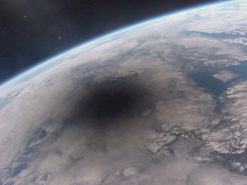 4
4


 https://www.youtube.com/watch?v=i93Z7zljQ7I
This discussion has been closed.
Categories
- All Categories
- 1.4M Health, Wellness and Goals
- 398.5K Introduce Yourself
- 44.7K Getting Started
- 261K Health and Weight Loss
- 176.4K Food and Nutrition
- 47.7K Recipes
- 233K Fitness and Exercise
- 462 Sleep, Mindfulness and Overall Wellness
- 6.5K Goal: Maintaining Weight
- 8.7K Goal: Gaining Weight and Body Building
- 153.5K Motivation and Support
- 8.4K Challenges
- 1.4K Debate Club
- 96.5K Chit-Chat
- 2.6K Fun and Games
- 4.8K MyFitnessPal Information
- 18 News and Announcements
- 21 MyFitnessPal Academy
- 1.5K Feature Suggestions and Ideas
- 3.2K MyFitnessPal Tech Support Questions