Space
Replies
-
InsertFunnyUsernameHere wrote: »How an eclipse looks from orbit.
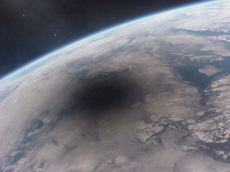
I saw it live from the other side. One of the most amazing things I've ever seen in my life.2 -
This content has been removed.
-
JustReadTheInstructions wrote: »InsertFunnyUsernameHere wrote: »How an eclipse looks from orbit.
I saw it live from the other side. One of the most amazing things I've ever seen in my life.
If I get a Solar lens for my telescope I can see mercury pass in front of the sun in November
[sarcasm] I would totally trust a solar lens being the only protection on a giant magnifying glass into my eye. [/sarcasm]0 -
Light from the Heart Nebula

What powers the Heart Nebula? The large emission nebula dubbed IC 1805 looks, in whole, like a human heart. The nebula glows brightly in red light emitted by its most prominent element: hydrogen. The red glow and the larger shape are all created by a small group of stars near the nebula's center. A close up spanning about 30 light years contains many of these stars is shown above .
This open cluster of stars contains a few bright stars nearly 50 times the mass of our Sun, many dim stars only a fraction of the mass of our Sun, and an absent microquasar that was expelled millions of years ago. The Heart Nebula is located about 7,500 light years away toward the constellation of Cassiopeia.0 -
This content has been removed.
-
This content has been removed.
-
JustReadTheInstructions wrote: »JustReadTheInstructions wrote: »InsertFunnyUsernameHere wrote: »How an eclipse looks from orbit.
I saw it live from the other side. One of the most amazing things I've ever seen in my life.
If I get a Solar lens for my telescope I can see mercury pass in front of the sun in November
[sarcasm] I would totally trust a solar lens being the only protection on a giant magnifying glass into my eye. [/sarcasm]
I know right? That's why I said "if". I need to make sure it's rated and actually for looking at the sun and not just like sun glasses
The safest way to view the transit yourself is to buy a purpose-built solar projection box.
These typically consist of a cardboard box with a small lens on one side. They project an enlarged image of the Sun onto a white cardboard sheet inside the box. Once the transit is over, they're also great for observing sunspots. They are safe to use, quick to set up, and ideal for use with children and groups.
Two example of low-cost cardboard solar projection boxes.0 -
This content has been removed.
-
JustReadTheInstructions wrote: »JustReadTheInstructions wrote: »JustReadTheInstructions wrote: »InsertFunnyUsernameHere wrote: »How an eclipse looks from orbit.
I saw it live from the other side. One of the most amazing things I've ever seen in my life.
If I get a Solar lens for my telescope I can see mercury pass in front of the sun in November
[sarcasm] I would totally trust a solar lens being the only protection on a giant magnifying glass into my eye. [/sarcasm]
I know right? That's why I said "if". I need to make sure it's rated and actually for looking at the sun and not just like sun glasses
The safest way to view the transit yourself is to buy a purpose-built solar projection box.
These typically consist of a cardboard box with a small lens on one side. They project an enlarged image of the Sun onto a white cardboard sheet inside the box. Once the transit is over, they're also great for observing sunspots. They are safe to use, quick to set up, and ideal for use with children and groups.
Two example of low-cost cardboard solar projection boxes.
That's all well and good for a solar eclipse but that will not help me see Mercury pass across
Actually it's made for the Mercury Pass and even has a lens in it to magnify it.0 -
This content has been removed.
-
This content has been removed.
-
JustReadTheInstructions wrote: »JustReadTheInstructions wrote: »JustReadTheInstructions wrote: »JustReadTheInstructions wrote: »InsertFunnyUsernameHere wrote: »How an eclipse looks from orbit.
I saw it live from the other side. One of the most amazing things I've ever seen in my life.
If I get a Solar lens for my telescope I can see mercury pass in front of the sun in November
[sarcasm] I would totally trust a solar lens being the only protection on a giant magnifying glass into my eye. [/sarcasm]
I know right? That's why I said "if". I need to make sure it's rated and actually for looking at the sun and not just like sun glasses
The safest way to view the transit yourself is to buy a purpose-built solar projection box.
These typically consist of a cardboard box with a small lens on one side. They project an enlarged image of the Sun onto a white cardboard sheet inside the box. Once the transit is over, they're also great for observing sunspots. They are safe to use, quick to set up, and ideal for use with children and groups.
Two example of low-cost cardboard solar projection boxes.
That's all well and good for a solar eclipse but that will not help me see Mercury pass across
Actually it's made for the Mercury Pass and even has a lens in it to magnify it.
I don't want to see the shadow on a paper I WANT TO LOOK AT THE SUN
I feel like I need to talk to you about looking at the sun now. Anyway here's a fun sun song.
The sun is mass of incandescent gas, a gigantic nuclear furnace
Where hydrogen is built into helium at a temperature of millions of degrees
Yo ho it's hot, the sun is not a place where we could live
But here on earth there'd be no life without the light it gives
They Might Be Giants - Why Does the Sun Shine? (The Sun is a Mass of Incandescent Gas) https://www.youtube.com/watch?v=3JdWlSF195Y 0
 -
Opportunity at Perseverance Valley

Opportunity had already reached Perseverance Valley by June of 2018. Its view is reconstructed in a colorized mosaic of images taken by the Mars Exploration Rover's Navcam. In fact, Perseverance Valley is an appropriate name for the destination. Designed for a 90 day mission, Opportunity had traveled across Mars for over 5,000 sols (martian solar days) following a January 2004 landing in Eagle crater.
Covering a total distance of over 45 kilometers (28 miles), its intrepid journey of exploration across the Martian landscape has come to a close here. On June 10, 2018, the last transmission from the solar-powered rover was received as a dust storm engulfed the Red Planet. Though the storm has subsided, eight months of attempts to contact Opportunity have not been successful and its trailblazing mission ended after almost 15 years of exploring the surface of Mars.1 -
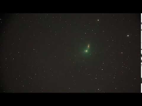
Comet Iwamoto Before Spiral Galaxy NGC 2903
 https://www.youtube.com/watch?v=cGfimZRZet8
It isn't every night that a comet passes a galaxy. Last Thursday, though, binocular comet C/2018 Y1 (Iwamoto) moved nearly in front of a spiral galaxy of approximately the same brightness: NGC 2903. Comet Iwamoto was discovered late last year and orbits the Sun in a long ellipse. It last visited the inner Solar System during the Middle Ages, around the year 648.
The comet reached its closest point to the Sun -- between Earth and Mars -- on February 6, and its closest point to Earth a few days ago, on February 13. The featured time-lapse video condenses almost three hours into about ten seconds, and was captured last week from Switzerland. At that time Comet Iwamoto, sporting a green coma, was about 10 light minutes distant, while spiral galaxy NGC 2903 remained about 30 million light years away. Two satellites zip diagonally through the field about a third of the way through the video. Typically, a few comets each year become as bright as Comet Iwamoto.
1 -

Cosmic Microwave Background
CMB is essentially electromagnetic radiation that is left over from the earliest cosmological epoch which permeates the entire Universe.
It is believed to have formed about 380,000 years after the Big Bang and contains subtle indications of how the first stars and galaxies formed.
While this radiation is invisible using optical telescopes, radio telescopes are able to detect the faint signal (or glow) that is strongest in the microwave region of the radio spectrum.
The CMB is visible at a distance of 13.8 billion light years in all directions from Earth, leading scientists to determine that this is the true age of the Universe. However, it is not an indication of the true extent of the Universe. Given that space has been in a state of expansion ever since the early Universe (and is expanding faster than the speed of light), the CMB is merely the farthest back in time we are capable of seeing.2 -
Doomed Star Eta Carinae

Eta Carinae may be about to explode. But no one knows when - it may be next year, it may be one million years from now. Eta Carinae's mass - about 100 times greater than our Sun - makes it an excellent candidate for a full blown supernova. Historical records do show that about 170 years ago Eta Carinae underwent an unusual outburst that made it one of the brightest stars in the southern sky. Eta Carinae, in the Keyhole Nebula, is the only star currently thought to emit natural LASER light.
This featured image brings out details in the unusual nebula that surrounds this rogue star. Diffraction spikes, caused by the telescope, are visible as bright multi-colored streaks emanating from Eta Carinae's center. Two distinct lobes of the Homunculus Nebula encompass the hot central region, while some strange radial streaks are visible in red extending toward the image right. The lobes are filled with lanes of gas and dust which absorb the blue and ultraviolet light emitted near the center. The streaks, however, remain unexplained.2 -
Reflections on vdB 9

Centered in a well-composed celestial still life, pretty, blue vdB 9 is the 9th object in Sidney van den Bergh's 1966 catalog of reflection nebulae. It shares this telescopic field of view, about twice the size of a full moon on the sky, with stars and dark, obscuring dust clouds in the northerly constellation Cassiopeia.
Cosmic dust is preferentially reflecting blue starlight from embedded, hot star SU Cassiopeiae, giving vdB 9 the characteristic bluish tint associated with a classical reflection nebula. SU Cas is a Cepheid variable star, though even at its brightest it is just too faint to be seen with the unaided eye. Still Cepheids play an important role in determining distances in our galaxy and beyond. At the star's well-known distance of 1,540 light-years, this cosmic canvas would be about 24 light-years across.1 -
NGC 4565: Galaxy on Edge

Magnificent spiral galaxy NGC 4565 is viewed edge-on from planet Earth. Also known as the Needle Galaxy for its narrow profile, bright NGC 4565 is a stop on many telescopic tours of the northern sky, in the faint but well-groomed constellation Coma Berenices.
This sharp, colorful image reveals the galaxy's bulging central core cut by obscuring dust lanes that lace NGC 4565's thin galactic plane. An assortment of other background galaxies is included in the pretty field of view, with neighboring galaxy NGC 4562 at the upper right.
NGC 4565 itself lies about 40 million light-years distant and spans some 100,000 light-years. Easily spotted with small telescopes, sky enthusiasts consider NGC 4565 to be a prominent celestial masterpiece Messier missed.
0 -
Good Morning From the Space Station!

1 -
SpaceX's Falcon 9 rocket survived a 'spicy' landing at sea after launching the first ever private moon mission

The rocket was returning from a mission to launch a trio of lunar craft into space, including a $100 million Israeli moon lander from SpaceIL — the first private mission to the moon.2 -
Japan’s Hayabusa 2 spacecraft lands on an asteroid

Japan’s Hayabusa 2 spacecraft has successfully landed on the surface of the asteroid Ryugu, a historic moment in space exploration that could provide fascinating details on the origins of life on Earth.
https://www.pbs.org/newshour/science/in-search-of-lifes-origins-japans-hayabusa-2-spacecraft-lands-on-an-asteroid1 -
Globular Cluster M55 from CFHT

The fifty-fifth entry in Charles Messier's catalog, M55 is a large and lovely globular cluster of around 100,000 stars. Only 20,000 light-years away in the constellation Sagittarius, M55 appears to earth-bound observers to be nearly 2/3 the size of the full moon. Globular star clusters like M55 roam the halo of our Milky Way Galaxy as gravitationally bound populations of stars known to be much older than stellar groups found in the Galactic disk.
Astronomers who make detailed studies of globular cluster stars can accurately measure the cluster ages and distances. Their results ultimately constrain the age of the Universe (... it must be older than the stars in it!), and provide a fundamental rung on the astronomical distance ladder. This stunning color image was made with the 3.6 meter CFHT telescope and spans about 100 light-years across the globular cluster M55.1 -
Magnetic Orion

Can magnetism affect how stars form? Recent analysis of Orion data from the HAWC+ instrument on the airborne SOFIA observatory indicate that, at times, it can. HAWC+ is able to measure the polarization of far-infrared light which can reveal the alignment of dust grains by expansive ambient magnetic fields.
In the featured image, these magnetic fields are shown as curvy lines superposed on an infrared image of the Orion Nebula taken by a Very Large Telescope in Chile.
Orion's Kleinmann-Low Nebula is visible slightly to the upper right of the image center, while bright stars of the Trapezium cluster are visible just to the lower left of center. The Orion Nebula at about l300 light years distant is the nearest major star formation region to the Sun.1 -
Sharpest Ultima Thule

On January 1, New Horizons swooped to within 3,500 kilometers of the Kuiper Belt world known as Ultima Thule. That's about 3 times closer than its July 2015 closest approach to Pluto. The spacecraft's unprecedented feat of navigational precision, supported by data from ground and space-based observing campaigns, was accomplished 6.6 billion kilometers (over 6 light-hours) from planet Earth.
Six and a half minutes before closest approach to Ultima Thule it captured the nine frames used in this composite image. The most detailed picture possible of the farthest object ever explored, the image has a resolution of about 33 meters per pixel, revealing intriguing bright surface features and dark shadows near the terminator. A primitive Solar System object, Ultima Thule's two lobes combine to span just 30 kilometers.
The larger lobe, referred to as Ultima, is recently understood to be flattened like a fluffy pancake, while the smaller, Thule, has a shape that resembles a dented walnut.0 -
A Charioteer's Comet

Still racing across planet Earth's night skies, Comet Iwamoto (C/2018 Y1) shares this pretty telescopic field of view with stars and nebulae of northern constellation Auriga, the Charioteer. Captured on February 27, Iwamoto's greenish coma and faint tail appear between a complex of reddish emission nebulae and open star cluster M36 (bottom right). The reddish emission is light from hydrogen gas ionized by ultraviolet radiation from hot stars near the region's giant molecular cloud some 6,000 light-years distant.
The greenish glow from the comet, less than 5 light-minutes away, is predominantly emission from diatomic carbon molecules fluorescing in sunlight. M36, one of Auriga's more familiar star clusters, is also a background object far beyond the Solar System, about 4,000 light-years away. Comet Iwamoto passed closest to Earth on February 12 and is outward bound in a highly elliptical orbit that will carry it beyond the Kuiper belt. With an estimated orbital period of 1,317 years it should return to the inner Solar System in 3390 AD.0 -
This content has been removed.
-

A SpaceX Falcon 9 rocket with the company's Crew Dragon spacecraft onboard launches from Launch Complex 39A, Saturday, March 2, 2019, at the Kennedy Space Center in Florida on its way to the International Space Station. The Demo-1 mission launched at 2:49 a.m. ET and was the first launch of a commercially built and operated American spacecraft and space system designed for humans as part of NASA's Commercial Crew Program. The mission will serve as an end-to-end test of the system's capabilities.1 -

"Super high tech zero-g indicator added just before launch!" wrote Musk on Twitter, sharing a photo of the plush Earth doll just four hours before a SpaceX Falcon 9 rocket lifted off on the Crew Dragon Demo-1 mission from NASA's Kennedy Space Center in Florida at 2:49 a.m. EST (0749 GMT) on Saturday. https://www.youtube.com/watch?v=Wa_m4p3TbN8

Expedition 58 flight engineer Anne McClain of NASA looks on as a Celestial Buddies' Planetary Pal Earth plush toy floats in zero-g on board SpaceX's first Crew Dragon spacecraft to dock to the International Space Station on Sunday, March 3, 2019. (NASA TV)
2 -
Celestial Alignment over Sicilian Shore

This was a sunrise to remember. About a month ago, just before the dawn of the Sun, an impressive alignment of celestial objects was on display to the east. Pictured, brightest and closest to the horizon, is the Moon. The Moon's orange glow is caused by the scattering away of blue light by the intervening atmosphere. Next brightest and next closest to the horizon is the planet Venus.
Compared to the Moon, Venus appears more blue -- as can (also) be seen in its reflection from the water. Next up is Jupiter, while the bright object above Jupiter is the star Antares. Although this display was visible from almost anywhere on planet Earth, the featured image was taken along a picturesque seashore near the city of Syracuse, on the island of Sicily, in the country of Italy. This month Saturn appears between Venus and Jupiter before sunrise, while Mars is visible just after sunset.1 -
X-Ray Superbubbles in Galaxy NGC 3079

What created these huge galactic superbubbles? Two of these unusual bubbles, each spanning thousands of light-years, were recently discovered near the center of spiral galaxy NGC 3079. The superbubbles, shown in purple on the image right, are so hot they emit X-rays detected by NASA's Earth-orbiting Chandra X-Ray Observatory. Since the bubbles straddle the center of NGC 3079, a leading hypothesis is that they were somehow created by the interaction of the central supermassive black hole with surrounding gas.
Alternatively, the superbubbles might have been created primarily by the energetic winds from many young and hot stars near that galaxy's center. The only similar known phenomenon is the gamma-ray emitting Fermi bubbles emanating from the center of our Milky Way Galaxy, discovered 10 years ago in images taken by NASA's Fermi satellite. Research into the nature of the NGC 3079 superbubbles will surely continue, as well as searches for high-energy superbubbles in other galaxies.1


This discussion has been closed.
Categories
- All Categories
- 1.4M Health, Wellness and Goals
- 397K Introduce Yourself
- 44.2K Getting Started
- 260.9K Health and Weight Loss
- 176.3K Food and Nutrition
- 47.6K Recipes
- 232.8K Fitness and Exercise
- 456 Sleep, Mindfulness and Overall Wellness
- 6.5K Goal: Maintaining Weight
- 8.7K Goal: Gaining Weight and Body Building
- 153.3K Motivation and Support
- 8.3K Challenges
- 1.3K Debate Club
- 96.5K Chit-Chat
- 2.6K Fun and Games
- 4.5K MyFitnessPal Information
- 16 News and Announcements
- 18 MyFitnessPal Academy
- 1.4K Feature Suggestions and Ideas
- 3.1K MyFitnessPal Tech Support Questions