September 2019 Monthly Running Challenge
Replies
-
4
-
Morning all, hope everyone are having good races/weekend runs.
I'm on call this weekend, and so far have had horrible call outs with next to no sleep. 5hrs of broken sleep per night is no fun. Still on call tonight so hopefully I 3ither get nothing at all (please!), or I get a magical call at 5am after I've had a solid 8hrs, and then I get most of a day off work.
Consequently I haven't started my weight programme, was going to try start yesterday. But thats OK. I'll start tomorrow (Monday) and incorporate it into my morning routine - weights then a run sounds wonderful.
Hubby is playing a chess tournament all day so today is going to be plant shopping, gardening and hopefully relaxing.5 -
Morning all, hope everyone are having good races/weekend runs.
I'm on call this weekend, and so far have had horrible call outs with next to no sleep. 5hrs of broken sleep per night is no fun. Still on call tonight so hopefully I 3ither get nothing at all (please!), or I get a magical call at 5am after I've had a solid 8hrs, and then I get most of a day off work.
Consequently I haven't started my weight programme, was going to try start yesterday. But thats OK. I'll start tomorrow (Monday) and incorporate it into my morning routine - weights then a run sounds wonderful.
Hubby is playing a chess tournament all day so today is going to be plant shopping, gardening and hopefully relaxing.
sounds like a super busy time for you! Hopefully you do get some rest today/tonight. Sounds like you have an awesome plan, incorporating your weight program into your morning routine. Before you know it, It'll be just another part of your day.0 -
So tired! But wanted to post and say I really enjoyed meeting @T1DCarnivoreRunner at the West Cancer Center 5k today. We forgot to get a photo together!
I had a great time, 1st in AG (actually 3rd of 41 in AG but both the master and grandmaster were from my group so I ended up 1st) and my husband was 3rd in his AG. I’ll write a proper race report later. Not a PR but a PR for this course which is a little long - last year my gps said 3.36, this year I got 3.27 miles but they routed us slightly differently - in fact all three years I have run it the course map was the same but the directions on course were different!12 -
September Running
09/01: 14.02 mile long run
09/02: Off, rest day
09/03: 6.07 mile fartlek
09/04: 5.18 mile run commute
09/05: 5.06 mile run commute
09/06: Off, rest day
09/07: 8.82 mile trail run
09/08: 14.09 mile trail long run
09/09: Off, rest day
09/10: 5.26 mile trail run
09/11: 9.07 miles - 3x12' TR/6' EZ
09/12: 6.25 mile run commute
09/13: 6.11 mile trail run
09/14: 16.57 mile trail long run
Total: 96.61 miles
Random updates because I haven't posted in over a week
- Officially registered for my first ultra! It's the Rosaryville 50K on 11/09
- Been doing a lot more trail running recently for obvious reasons. I got a new pair of trail running shoes (a bit more cushioned than the trail shoes I had been using) and they are SO comfortable and awesome right out of the box
- I also got a new GPS watch (garmin FR 645 music)- it is super pretty and I love that it has a barometric altimeter and the ability to make/follow courses. I've already made a bunch of routes around rock creek park that I can't wait to try out
- Today's long run (16.6 miles) was the longest I've ran in over a year and it felt surprisingly good! I ran the first 13ish miles with a woman from the trail running group. We may have gone a little bit too fast for it to be a true easy pace for me (we were hitting low 10s and high 9s with some decent elevation) and I didn't hydrate/refuel nearly enough since I was too busy chatting away. I need to do a better job with this on my long runs from here on out because I can get away with underhydrating/fueling on a 16 miler but definitely not come race day!
Upcoming Races
10/05: Black Hill XC - 10K
11/09: Rosaryville 50K
12/01: Space Coast Half Marathon
12/08: Jingle Bell Jog - 8K
12/15: Seneca Slopes XC - 9K
9 -
@ariceroni 50k are fun. Nice running today, you've got plenty of time to rock your ultra!2
-
rheddmobile wrote: »So tired! But wanted to post and say I really enjoyed meeting @T1DCarnivoreRunner at the West Cancer Center 5k today. We forgot to get a photo together!
I had a great time, 1st in AG (actually 3rd of 41 in AG but both the master and grandmaster were from my group so I ended up 1st) and my husband was 3rd in his AG. I’ll write a proper race report later. Not a PR but a PR for this course which is a little long - last year my gps said 3.36, this year I got 3.27 miles but they routed us slightly differently - in fact all three years I have run it the course map was the same but the directions on course were different!
@rheddmobile I enjoyed meeting you as well! I'm sorry I didn't stick around afterwards to talk more.
BTW, my GPS showed 3.24 miles: https://connect.garmin.com/modern/activity/4057406180 I realize tangents are not always perfect, but it does seem like a lot of extra for the race distance. *shrugs* It's been a year since I've done a 5K race, and that was my PR... a week before my marathon PR. This was far from a PR 5K, but I acknowledge taking a few walk breaks and I didn't exactly have a great morning before-hand. Nonetheless, I enjoyed the event as I I had forgotten how much fun the 5K races can be.
As a result, I am thinking of doing some fun Halloween 5K's next month (Nashville and/or Little Rock - logistically it is possible to do both Top Buttons Nashville Halloween Fun Run 5K in the morning and drive to Little Rock for Creep 'N' Crawl 10K or 5K in the evening on 10/26). I stopped by the Halloween store today while I was in Memphis and got a costume for a prisoner - orange jumpsuit with "Department of Corrections" on it; and some toy handcuffs that I can cut apart as though I had broken loose and am "on the run." It could be a lot of fun!
For now, though, I'm looking forward to the Air Force Marathon next weekend (Dayton, OH).
Mileage for today - 3.22 miles warm-up, then let's say 3.1 miles for the 5K:
8 -
@T1DCarnivoreRunner and @rheddmobile great job on your 5K! WTG on your 1st place AG! It's so cool that y'all got to meet IRL!3
-
September Goal: 160km
02/9: 5.11
03/9: 8.11
04/9: 6.73
06/9: 8.46
07/9: 14.06
09/9: 6.15
11/9: 13.05
13/9: 8.44
14/9: 16.14
Total KM run: 86.25
I realised on my run today that I'm going to have to start thinking about hydration and fueling again. During the winter I don't bother taking water on anything less than about 18km but I got so dehydrated today I ended up with that really attractive white scum around the corners of my mouth I guzzled a glass of water so fast when I got home I nearly choked.
I also never fuel on any run less than 21km and I always run fasted since I usually roll straight out of bed and don't want to bother eating or drinking first, but I only had some avocado on toast for dinner last night and that clearly wasn't enough to sustain me through my run this morning because I was about ready to lay down and quit by 13km. I kept going because I had to get home somehow and walking would take way too long, but it was rough. In a few weeks my long runs are going to be all longer than 21km so I need to make sure I eat a good dinner the night before and remember to bring gels!
@7lenny7 sounds like a great run!
@PastorVincent I'm loving all the pictures. I find it fascinating to see where others live/run all over the world
@rheddmobile Woohoo! Great job on the AG win and place for your husband!7 -
Lazy_Bones_85 wrote: »Question: My 15K is in 5 weeks. How far of a pace run should I be doing? I’m at 4.5M which is just shy of half the distance. Should I increase by another .5 or 1 over the next few weeks or is half the distance appropriate? My long runs over the next few weeks will take me to 1 mile over the race distance. The plan I’m following is 2 easy runs, an interval run, a long run, and a pace run. I think it may be a little too speed heavy. Maybe I should do a pace run and intervals every two weeks instead? Normally intervals are on Monday, Pace is Thursday. I don’t want to overtrain. But I don’t want to be under prepared. Outside of running, I’m quite active and my legs are feeling fatigued.
Well, first off, do not worry. You could run that race any week now based on what I read in your reports. You have run the full distances more than once in the past month.
As for the pace runs, I would say no need to go beyond 80% of the distance, but some would say 50% is fine. Remember during training, if you are doing it right, you are ALWAYS running on tired legs. That is why you tapper before a race that you really want to perform in.
Also, you can definitely do 100% or 125% at pace - BUT your risk for injury goes up the harder you push. I am training for a 10-mile race and am doing my pace runs at 10-11 miles, but I have been running for well over a decade now and I know when to stop and walk, when to DNS or DNF.
For most people, 50%-80% is probably the right range. Most of all listen to your body and adapt as you go.
2 -
polskagirl01 wrote: »PastorVincent wrote: »MNLittleFinn wrote: »So... a little explanation about me saying do not be me last night.... I may have signed up for another race already.........LOL
Oh in that case I am you
Signed my entire family up for a new race last night! HA!
Were we all affected by the 13th? And I don't even believe in that! But I did a mass signup on a bunch of races last night, too!
Edit to add: I'm guessing my races (all of them combined) are a lot shorter than yours. What did you sign up for?????
Actually probably not this time. The race is 4-5 miles, but it is an obstacle course run. "Stop Drop and Run" - put no by the fire department. It is totally a "for fun" race.4 -
So I did it! First half marathon done and feels really good to have completed it! I’ll write up my first ever race report tomorrow, but in short I did it 2:25! Garmin and strava had differnent final distances which were more than 13.1.. is that normal? Cause I had better times on those than actual chip time lol
17 -
polskagirl01 wrote: »PastorVincent wrote: »Went expoloering again at lunch. This time I used a device the wetlanders call a bridge and crossed the river to see what was over there. Plenty of pictures in the spoiler tags.


These are all #shotoniphone
I keep thinking I should go back with my camera, but that would take a special trip and planing. iPhone is easier for these random wanderings.
Love the pictures! The GAP trail starts there at the fountain on the Point, if you haven't already checked that out! When I biked it a few years ago, that section was a little confusing though as far as where the trail actually was (Or maybe I was just disoriented from cycling all day and now having less than a mile to go and not being able to follow directions.)
Yeah. It is part of the rails to trail project that connects Washington State with DC. The idea is you can bike/run the entire way on the one trail, but here in Pittsburgh, it is very confusing. Still figuring it out.
0 -
rheddmobile wrote: »So tired! But wanted to post and say I really enjoyed meeting @T1DCarnivoreRunner at the West Cancer Center 5k today. We forgot to get a photo together!
I had a great time, 1st in AG (actually 3rd of 41 in AG but both the master and grandmaster were from my group so I ended up 1st) and my husband was 3rd in his AG. I’ll write a proper race report later. Not a PR but a PR for this course which is a little long - last year my gps said 3.36, this year I got 3.27 miles but they routed us slightly differently - in fact all three years I have run it the course map was the same but the directions on course were different!
Well done!0 -
hamsterwheel6 wrote: »So I did it! First half marathon done and feels really good to have completed it! I’ll write up my first ever race report tomorrow, but in short I did it 2:25! Garmin and strava had differnent final distances which were more than 13.1.. is that normal? Cause I had better times on those than actual chip time lol
YAY!!!! CONGRATS!!!0 -
hamsterwheel6 wrote: »So I did it! First half marathon done and feels really good to have completed it! I’ll write up my first ever race report tomorrow, but in short I did it 2:25! Garmin and strava had differnent final distances which were more than 13.1.. is that normal? Cause I had better times on those than actual chip time lol
Strava is wrong.") Strava counts "moving time" only so it subtracts off any time you were not moving fast enough for it to think you were running. Garmin does not do that. There is a setting someplace in Strava to turn off that feature, but I forget where. 0
Strava counts "moving time" only so it subtracts off any time you were not moving fast enough for it to think you were running. Garmin does not do that. There is a setting someplace in Strava to turn off that feature, but I forget where. 0 -
rheddmobile wrote: »So tired! But wanted to post and say I really enjoyed meeting @T1DCarnivoreRunner at the West Cancer Center 5k today. We forgot to get a photo together!
I had a great time, 1st in AG (actually 3rd of 41 in AG but both the master and grandmaster were from my group so I ended up 1st) and my husband was 3rd in his AG. I’ll write a proper race report later. Not a PR but a PR for this course which is a little long - last year my gps said 3.36, this year I got 3.27 miles but they routed us slightly differently - in fact all three years I have run it the course map was the same but the directions on course were different!
Great job!0 -
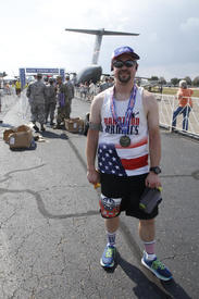
@rheddmobile So sorry to read about the break in to your car and theft of all of your running gear. I know that is upsetting and replacing everything is going to be a pain. I am glad that you had your id's and keys with you. Nice that your picture is on the flyer for the race. Hope you can get a copy of the photo for yourself!
@shanaber Looks like a nice place to run and then walk and relax. Glad you had such a great day...on the 11th. I'm so far behind on this thread! LOL
Welcome @anichkata1 !
@Avidkeo Glad the mold wasn't as bad as you expected. Good luck with the weight loss challenge! You can do it!
Yeah @polska_girl ! Glad you don't have to have surgery!
@7lenny7 I really don't eat pickles. I wonder if vinegar alone would do the same thing. Just asking for the future, if I ever run enough to get cramps. So far, that hasn't happened. (Knock on wood.) 10K has been my longest run.
Glad your Friday the 13th Full Moon Howl went well! The pictures are great.
@polskagirl01 I wouldn't want to run in an area with wild boars either. That looks like a neat place though. Which virtual race are you doing?
0 -
PastorVincent wrote: »polskagirl01 wrote: »PastorVincent wrote: »Went expoloering again at lunch. This time I used a device the wetlanders call a bridge and crossed the river to see what was over there. Plenty of pictures in the spoiler tags.
These are all #shotoniphone
I keep thinking I should go back with my camera, but that would take a special trip and planing. iPhone is easier for these random wanderings.
Love the pictures! The GAP trail starts there at the fountain on the Point, if you haven't already checked that out! When I biked it a few years ago, that section was a little confusing though as far as where the trail actually was (Or maybe I was just disoriented from cycling all day and now having less than a mile to go and not being able to follow directions.)
Yeah. It is part of the rails to trail project that connects Washington State with DC. The idea is you can bike/run the entire way on the one trail, but here in Pittsburgh, it is very confusing. Still figuring it out.
What?! A trail all the way from Washington State to DC?! How did I not know about this? That would be a fantastically long trail!1 -
I got out again tonight for another 3 mile run so I would be caught up. There are paved trails that connect with my neighborhood, and as I was on one trail, I smelled some animal that died nearby. My mind, of course, then wandered to the thought that I was going to be one of those runners that finds a dead human body, so I quickly headed out of there! 😂 It didn’t help that I was listening to a murder podcast while I ran...
9/1: 3
9/2: 6.2
9/5: 2 (cadence drills)
9/7: 3
9/8: 4
9/9: ST
9/10: 2
9/11: ST and swimming
9/14: 3 (hill repeats), 3 more
26.2/40 miles
7 -
marisap2010 wrote: »I got out again tonight for another 3 mile run so I would be caught up. There are paved trails that connect with my neighborhood, and as I was on one trail, I smelled some animal that died nearby. My mind, of course, then wandered to the thought that I was going to be one of those runners that finds a dead human body, so I quickly headed out of there! 😂 It didn’t help that I was listening to a murder podcast while I ran...
9/1: 3
9/2: 6.2
9/5: 2 (cadence drills)
9/7: 3
9/8: 4
9/9: ST
9/10: 2
9/11: ST and swimming
9/14: 3 (hill repeats), 3 more
26.2/40 miles
don't worry. Only "joggers" find bodies, not runners. Just keep reminding yourself that you're a runner and it's all good.8 -
T1DCarnivoreRunner wrote: »PastorVincent wrote: »polskagirl01 wrote: »PastorVincent wrote: »Went expoloering again at lunch. This time I used a device the wetlanders call a bridge and crossed the river to see what was over there. Plenty of pictures in the spoiler tags.
These are all #shotoniphone
I keep thinking I should go back with my camera, but that would take a special trip and planing. iPhone is easier for these random wanderings.
Love the pictures! The GAP trail starts there at the fountain on the Point, if you haven't already checked that out! When I biked it a few years ago, that section was a little confusing though as far as where the trail actually was (Or maybe I was just disoriented from cycling all day and now having less than a mile to go and not being able to follow directions.)
Yeah. It is part of the rails to trail project that connects Washington State with DC. The idea is you can bike/run the entire way on the one trail, but here in Pittsburgh, it is very confusing. Still figuring it out.
What?! A trail all the way from Washington State to DC?! How did I not know about this? That would be a fantastically long trail!
Yep. It is not complete yet, but I think it is over 50% done now. Details here:
https://www.railstotrails.org/greatamericanrailtrail/1 -
No run today, instead took the camera to the aviary and got a few shots...
Of some eagles:


 9
9 -
No run today, instead took the camera to the aviary and got a few shots...
of some flowers

 5
5 -
No run today, instead took the camera to the aviary and got a few shots...
and some random birds:


 5
5 -
@PastorVincent nice pictures!0
-
MNLittleFinn wrote: »@PastorVincent nice pictures!
Thanks!0 -
September goal: try to keep up
9/1 3.30
9/2 2.00
9/3 rest
9/4 4.70
9/5 rest
9/6 3.12
9/7 Travel to> O'ahu CME conference<travel from
9/8 3.00
9/9 snorkel 3 hours
9/10 lazy
9/11 4.5
9/12 rest
9/13 2.80
9/14 3.30
Total : 27.82
Upcoming races:
Revel Kulia Half Marathon 1/18/20
Ticker is my goal for 2019 and progress to date:
5 -
PastorVincent wrote: »
If you care enough...
You can look at the map it routed and see how close it was to tracking you correctly. If it is way off you can use a free program called "Google Earth" to draw the route you actually ran on a map and get the correct distance. Then compare with the time form your phone and use that to figure out your average pace and actual 5k time.
Or you can do what I probably would do, ignore it and carry on.
As for the GPS watch, I do not know your financial means, but you can sometimes find used ones cheaply on Crag's List or the Facebook Market. Just takes time and patience to dig through the mess and find them. Ebay is another place if you are a savy shopper you can find used stuff cheap.
Thanks @PastorVincent! I am going to look at google earth, because yesterday I did another 5k according to my phone which felt shorter that it normally measures, and I got under 30 minutes for the first time in about six years, and I don't know whether to be thrilled or not (obviously I am, but a bit unsure).
Unfurtuntely we don't really have Craig's list or fb market here, and ebay doesn't work. I think I will wait til Christmas and will get one back in the UK where they are much cheaper anyway. Thanks for the suggestions though. And I love all your photos, thanks for sharing.
@rheddmobile and @T1DCarnivoreRunner and @hamsterwheel6 congrats on the races, excellent times all round!
Today should be a long run as part of my bridge to 10k program. Feeling pretty lazy though, not sure I'll make it...
7 -
T1DCarnivoreRunner wrote: »PastorVincent wrote: »polskagirl01 wrote: »PastorVincent wrote: »Went expoloering again at lunch. This time I used a device the wetlanders call a bridge and crossed the river to see what was over there. Plenty of pictures in the spoiler tags.
These are all #shotoniphone
I keep thinking I should go back with my camera, but that would take a special trip and planing. iPhone is easier for these random wanderings.
Love the pictures! The GAP trail starts there at the fountain on the Point, if you haven't already checked that out! When I biked it a few years ago, that section was a little confusing though as far as where the trail actually was (Or maybe I was just disoriented from cycling all day and now having less than a mile to go and not being able to follow directions.)
Yeah. It is part of the rails to trail project that connects Washington State with DC. The idea is you can bike/run the entire way on the one trail, but here in Pittsburgh, it is very confusing. Still figuring it out.
What?! A trail all the way from Washington State to DC?! How did I not know about this? That would be a fantastically long trail!
I wonder how much of it follows roads though. Almost all of the GAP [Great Allegheny Passage, which then connects to the C&O Towpath] is on a rail-trail and gets you Pittsburgh-D.C.
In Pittsburgh, if you can just get past the first mile or so, it gets more obvious where the trail is.1


This discussion has been closed.
Categories
- All Categories
- 1.4M Health, Wellness and Goals
- 398.1K Introduce Yourself
- 44.7K Getting Started
- 261K Health and Weight Loss
- 176.4K Food and Nutrition
- 47.7K Recipes
- 233K Fitness and Exercise
- 462 Sleep, Mindfulness and Overall Wellness
- 6.5K Goal: Maintaining Weight
- 8.7K Goal: Gaining Weight and Body Building
- 153.5K Motivation and Support
- 8.4K Challenges
- 1.4K Debate Club
- 96.5K Chit-Chat
- 2.6K Fun and Games
- 4.8K MyFitnessPal Information
- 12 News and Announcements
- 21 MyFitnessPal Academy
- 1.5K Feature Suggestions and Ideas
- 3.2K MyFitnessPal Tech Support Questions