Hiking for fitness
Replies
-
@NorthCascades ...wonderful pictures. My love for PNW outdoors keeps on growing. Cheers again0
-
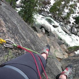
Mount Si Hike, WA, July 2016. This a a hard trail with the last-hop scramble testing fitness to the limit.0
-
Looking at some of this pictures again, I realized how awesome Stargazing might be here in the PNW2
-
Nice pics from Si!

When I tried to get into WAC, part of the admission criteria was having to do Mt Si from the trailhead to the Haystack in 2 hours with a 30 pound pack. I think I got 2:05 but they called it close enough ... and then didn't have room for me.0 -
sireenmalik2014 wrote: »Mount Si Hike, WA, July 2016. This a a hard trail with the last-hop scramble testing fitness to the limit.
Beautiful!!1 -
NorthCascades wrote: »Nice pics from Si!
When I tried to get into WAC, part of the admission criteria was having to do Mt Si from the trailhead to the Haystack in 2 hours with a 30 pound pack. I think I got 2:05 but they called it close enough ... and then didn't have room for me.
This was a good hike - my first hard one. It was great for building confidence and also making me aware how much I have to improve quads still working on it.
0 -
queenliz99 wrote: »sireenmalik2014 wrote: »Mount Si Hike, WA, July 2016. This a a hard trail with the last-hop scramble testing fitness to the limit.
Beautiful!!
Thanks, how about you, do you hike regularly?
0 -
Have you done Granite, on I-90 (exit 47)? Similar stats, but the last mile or so is above tree line, so you get views of Rainier and Keechelus.
Iron Peak in the Teanaway is probably about the same mileage and elevation gain (?) but very little woods to hike through. Fantastic view of the Enchantment Range from the top, and of Daniel/Himan.0 -
I hike for fun and fitness, if you want to add me as a friend just make about hiking so I know how you found me. Unfortunately, I've been working on my master's degree and have had less time to hike lately than I would like. I'll be done in Oct. (assuming all goes well) and will hike a lot next year.
Top of my bucket list (hopefully July or Aug. next year, and I need to find someone to go with me for obvious reasons... been trying to get my brother to do this, but he is uncommitted) - park a car at Waterton Lakes National Park and ride back to Bowman Lake trailhead, Glacier National Park... hike over Brown's pass, and then end up in Canada (there is a hiking trail that goes between the 2 parks across the border). Other less spectacular hikes will happen before / after then, but that is a long-standing dream.
If I had to do it solo, the transportation to return to Bowman Lake trailhead is very challenging: Bus along the eastern side of Waterton Lakes and Glacier, then Glacier NP bus half-way across Going to the Sun Road, 2nd Glacier NP bus to Lake MacDonald, taxi cab up to Polebridge, and then walk the rest of the way (commercial vehicles, including taxis are prohibited beyond Polebridge). By that time, even catching the first bus out of Waterton puts me walking up 10-11 miles to Bowman Lake trailhead at around 11pm in some of the heaviest grizzly territory in the lower 48. And THAT is why I need a 2nd person to make 2 cars work.2 -
Very Large Herd Of Mountain Goats Gathers Near Mt. Baker
http://nwsportsmanmag.com/headlines/large-herd-mountain-goats-gathers-near-mt-baker/
These are majestic creatures. Ptarmigan Ridge is supposed to be the best place to see them on Mt Baker. I've seen the most goats in the Teanaway and Enchantments. If you see one, pee on a rock for it.4 -
sireenmalik2014 wrote: »queenliz99 wrote: »sireenmalik2014 wrote: »Mount Si Hike, WA, July 2016. This a a hard trail with the last-hop scramble testing fitness to the limit.
Beautiful!!
Thanks, how about you, do you hike regularly?
Yes, almost everyday! San Diego county has hiking trails everywhere.
http://www.sandiegohikers.com/
2 -
I love hiking for fun and fitness! I live next to a state park in Vermont that I visit about four times a week (when weather permits) for a short 3-ish mile hike before work. It's not super strenuous, but there is a nice incline, and I usually throw in some trail running. I do a longer, more strenuous hike about once a month, or as time allows, and try to do a multi-day backpacking trip once a year.
When the trails are too icy or the temperature is below 25, I do some weightlifting and use the stair master at the gym to prepare for steep climbs.
It's such an incredibly well-rounded activity, and something that I really look forward to doing throughout my week and year. The longer backpacking trips are fun to prepare for, too, because they give you extra incentive to get hikes in more regularly!1 -
I hike every day.
Twice per week I strap on a 60 pound weighted vest and go 4 miles on a bike path. Other times I take a slow, barefoot hike through the woods with a swim in a nearby lake.
It's a great way to connect with nature and get the blood pumping. Nothing feeds the inside of a man quite like the outside in nature.
It's difficult expressing this in mere words. In addition to hiking, I have days where I'm biking, lifting weights and running. They key to health and fitness is finding what you enjoy, then just throw yourself into it.
HAPPY HIKING FOLKS!")

2 -
I'm actually quite scared to go hiking again. Falling and getting rescued was a traumatic experience got me. Any advice to get over the fear?0
-
I'm actually quite scared to go hiking again. Falling and getting rescued was a traumatic experience got me. Any advice to get over the fear?
I'm a 62 year old, 3-4 days a week hiker. I haven't had the misfortune of hurting myself badly on any hike over the past 45 years, but I understand your fears (I don't trail run any more because of a nasty face plant that left me looking less than pretty). My advice is to go with other people and just be really cautious, maybe do some short trail hikes on fairly flat terrain to build your confidence back up.1 -
Get back on that horse!1
-
I hike every week, usually at Devil's Lake State Park near Baraboo, WI.
I plan to go and hike Kilimanjaro next year for my sabbatical from work.2 -
NorthCascades wrote: »Have you done Granite, on I-90 (exit 47)? Similar stats, but the last mile or so is above tree line, so you get views of Rainier and Keechelus.
Iron Peak in the Teanaway is probably about the same mileage and elevation gain (?) but very little woods to hike through. Fantastic view of the Enchantment Range from the top, and of Daniel/Himan.
@NorthCascades Granite in two weeks. This weekend I'm doing Stephens Pass - a moderate trail.
0 -
I'm actually quite scared to go hiking again. Falling and getting rescued was a traumatic experience got me. Any advice to get over the fear?
@Joenali - Start with small steps. Build your confidence. Suggest doing a few easy and moderate hikes before doing the hard trails, even if it takes months or years. I use AllTrails app on iOS. Which gives a huge list of each category (easy, moderate and hard). Start with easy trails. The confidence might come back quicker than you think.
Also, keep company. Go in a group. We don't know each other but if it helps I can give you company.
Conquer Your Fear.
0 -
-
Sunday morning hike.
Breakfast at Stan's Overlook (no, not at Tiffanys)
Fitness: Getting better. 2.2miles hike to Stan's Overlook, Rattle Snake Mountain, WA under 50mnts. Out and back 90mnts (excluding rest). Moderate incline ....but still.2 -
What a great thread! I'm an occasional hiker but with jobs and kids, it's a little hard. My husband is talking about a getaway in October at Yellowstone and asked what in the world we could do for two days? HIKE! I don't know how he didn't come to that himself. lol
1 -
@quiltlovinlisa Hopefully the weather changes and we get snow before you go, the smoke from the fires can put a damper on things.1
-
quiltlovinlisa wrote: »What a great thread! I'm an occasional hiker but with jobs and kids, it's a little hard. My husband is talking about a getaway in October at Yellowstone and asked what in the world we could do for two days? HIKE! I don't know how he didn't come to that himself. lol
Go for it
I told everybody around me that Saturday mornings belong to me. That I will go hiking. Surprisingly, it was far easier that I thought; everything than organizes around the Saturdayschedule. A little my-time is so important. I realize now that my relationships are improving a lot, as a result of this little activity,1 -
Just wrapped up my own weekly hike here - 12.5 miles / 2300 ft. elevation change. Took a different trail up the bluffs at Devil's Lake - I think this new trail is my favorite in terms of view. I'll have to bring a camera next time and snap some photos, you can see for miles of woodlands and lakes. I'm sure it will look stunning come fall, too!2
-
rankinsect wrote: »Just wrapped up my own weekly hike here - 12.5 miles / 2300 ft. elevation change. Took a different trail up the bluffs at Devil's Lake - I think this new trail is my favorite in terms of view. I'll have to bring a camera next time and snap some photos, you can see for miles of woodlands and lakes. I'm sure it will look stunning come fall, too!
Awesome. I take my iPhone with me. It measures distance, and then I use this app to calculate lost calories.
And, it has a camera. Very useful that it is light and can snap decent pics.
Looking forward to seeing your hike's pics.
0 -
sireenmalik2014 wrote: »rankinsect wrote: »Just wrapped up my own weekly hike here - 12.5 miles / 2300 ft. elevation change. Took a different trail up the bluffs at Devil's Lake - I think this new trail is my favorite in terms of view. I'll have to bring a camera next time and snap some photos, you can see for miles of woodlands and lakes. I'm sure it will look stunning come fall, too!
Awesome. I take my iPhone with me. It measures distance, and then I use this app to calculate lost calories.
And, it has a camera. Very useful that it is light and can snap decent pics.
Looking forward to seeing your hike's pics.
I did have my phone, I suppose I could have used its camera. But then part of me thinks I wasted money buying a nice expensive camera if I do that all the time 2
2 -
OP: You are aware of NWHikers, yeah? There's also OregonHikers. Both are great groups and if you spend any time around them, you will run into people you recognize eventually.
I didn't hike for fitness, though. I hiked to build endurance for running, of all things if you can believe it. Well, and for the pay off destinations/views. Looking forward to getting back to it once I hit 190 lbs. again.
My only tips to you (anyone, in fact) are:
1. Always tell someone where you're going and when you'll be back. Leave a note in your car, too.
2. Become proficient at being able to land nav with a compass and a quadrangle (and carry both for the area you are exploring).
3. Carry enough to be able to spend the night (or two) outdoors and not die from exposure.
4. If you can afford it, buy a satellite phone.
5. Car clouting can be horrid. Don't leave anything in plain sight. At the worst THs, leave your glove box/center console open so can be seen to be empty from the outside of your locked vehicle.
Hiking in the PNW is near-deadly, or deadly even, for many every year. And I've repeatedly seen people get lost and have to be rescued within wilderness areas that one can easily walk across in a solid day and are bounded by major roadways on every side.
Diet is the same as it always is if you are still wanting to lose weight; eat at a caloric deficit and eat back half your calculated calorie expenditure during hiking. Always err on the side of underestimating expenditure vs. over. Homemade dehydrated meals that you "freezer bag" rehydrate rock for figuring out calorie menus if doing multis.
Finally, there's a lovely hot springs up Stevens Pass way that is a wonderful way to end a hard day of hiking, but it requires owner permission in advance: http://scenichotsprings.blogspot.com3 -
sireenmalik2014 wrote: »Today in Oregon. Multnomah Falls, OR
There's a nice loop if you go up the Multnomah Falls trail and come down the Wahkeena Falls trail. It's an easy/moderate 5 miles RT or so, IIRC. And there's even a great spoiler (I'm not going to explain it here) side trail if you ever do it.
1 -
@quiltlovinlisa Hopefully the weather changes and we get snow before you go, the smoke from the fires can put a damper on things.
We were just there last weekend (we live in South Eastern Idaho, so it was a day trip) and it wasn't too bad most of the time. Of course that could change drastically by October, we'll see. Hiking Yellowstone is my favorite all time thing, so I'm hopeful. 1


Categories
- All Categories
- 1.4M Health, Wellness and Goals
- 397.1K Introduce Yourself
- 44.2K Getting Started
- 260.9K Health and Weight Loss
- 176.3K Food and Nutrition
- 47.6K Recipes
- 232.8K Fitness and Exercise
- 457 Sleep, Mindfulness and Overall Wellness
- 6.5K Goal: Maintaining Weight
- 8.7K Goal: Gaining Weight and Body Building
- 153.4K Motivation and Support
- 8.3K Challenges
- 1.3K Debate Club
- 96.5K Chit-Chat
- 2.6K Fun and Games
- 4.6K MyFitnessPal Information
- 16 News and Announcements
- 18 MyFitnessPal Academy
- 1.4K Feature Suggestions and Ideas
- 3.1K MyFitnessPal Tech Support Questions