Hiking for fitness

MountainSam
Posts: 46 Member
I would like to connect (with) folks who are into hiking. I moved to Seattle area a year ago, and started hiking a few months back. It has done wonders to my mental and physical health: I have lost weight; my energy level is up; sleep better; better focus; me-time helps me de-stress, ... the list goes on. I hit the trails every Saturday morning. During the weekdays spend some time in the gym to improve my fitness. Honestly, it is more mental strength right now than my fitness but I keep raising the bar every weekend - one little step at a time.
I would like other hikers to share their experiences, training programs, diet plans, motivational tips, tips on trail heads, .., or any other interesting insight.
I am certain this will motivate other people to take up this great outdoor activity.
Sam
Redmond, WA
I would like other hikers to share their experiences, training programs, diet plans, motivational tips, tips on trail heads, .., or any other interesting insight.
I am certain this will motivate other people to take up this great outdoor activity.
Sam
Redmond, WA
17
Replies
-
I'm in Colorado and I LOVE hiking. I struggle with anxiety and hiking does wonders for it. Feel free to add me!6
-
Well the last time I went hiking I broke my ankle and had to have search and rescue bring me down. That was fun!2
-
Hiking is my thing!2
-
F**k that.
Hike for scenery, not fitness. Fitness is just the icing on the cake.
Which are your favorite trails? Have you explored NOCA much? Can I post (local) photos in your thread?2 -
Just don't hike Mailbox!0
-
North Cascades - absolutely do post pictures, I have not been to Noca but will put that on my list. Thanks for the tip.
0 -
-
-
-
Well the last time I went hiking I broke my ankle and had to have search and rescue bring me down. That was fun!
I hope it was free. @sireenmalik2014 should know that in our area, search and rescue is ALWAYS free, in large part for the safety of the people doing the rescue work (who are mostly volunteers). I also hope you're doing ok.
Here's a great video of a recent SAR mission on Dragontail Peak, in the Enchantment Lakes Basin near Leavenworth.sireenmalik2014 wrote: »Recent hike: Mailbox Peak, WA
You're in good shape if you did Mailbox Peak.
But I want you to make me a promise. No more "close in" hikes until the rainy season begins. I'm going to send you to more spectacular places.1 -
@NorthCascades - appreciate that tip; I didn't know about the free rescue. That is a good way to encourage the outdoor activities.
I just checked the NoCA trails. That area is breathtakingly beautiful. I am going to go there sooner than later. I will start with the day trips0 -
sireenmalik2014 wrote: »North Cascades - absolutely do post pictures, I have not been to Noca but will put that on my list. Thanks for the tip.
North Cascades National Park (NOCA or NCNP) is full of the most beautiful places in our state. The nearby Pasayten Wilderness is fantastic as well.
My favorite hike is Cascade Pass, here are a couple photos. It's outside the town of Marblemount, on State Route 20. This is much, much easier than Mailbox Peak. If you want to make it harder, continue on to Sahale Glacier Camp.
Now the downside: it takes about 2 hours to drive to Marblemount from Seattle, and then another 45 to 60 minutes to drive Cascade River Road to the trailhead. (I biked Cascade River Road this year, see the trip report here.)
This is just below (west of) Cascade Pass.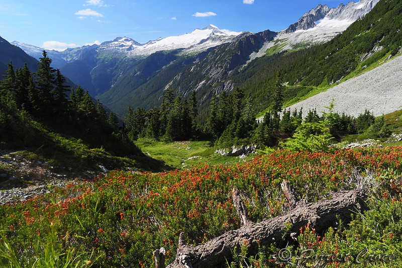
Here's Sahale Glacier Camp.
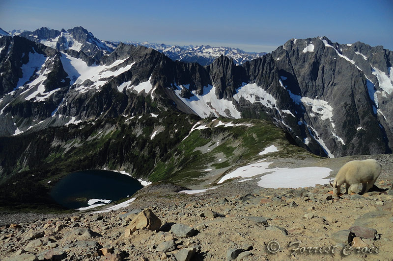

The Cascade Pass trail ends in the wilderness where the old Upper Stehekin Valley Road begins, cars and even bikes are illegal here so it's only for hiking. Most people consider it an extension of the trail. I spent three days hiking from Cascade Pass to Stehekin. This is how it ended.

 9
9 -
Next thing I want to talk about is a tree, the alpine (Lyall's) larch. It's a deciduous (like a maple) which means that it drops its leaves in the fall. But it's also a conifer (like a pine) which means it has needles and cones. So you'd look at it and think it's an evergreen, but it's not. Anyway, the cool part is that it turns golden yellow in the fall, which is coming up. This is an absolute must see, in the fall you should mysteriously get sick and be unable to go to work for a couple days. It's called larch fever and it's a common ailment in these parts.
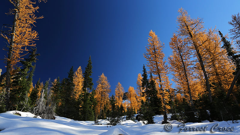

These only live (here) at high altitude (around 5k+) on the east slope of the Cascades, north of around Cle Elum. You can find them in the Teanaway, Enchantments, Chelan Sawtooths, NOCA, and the Pasayten. These are a must see in their season. Also, the needles are very soft to the touch, like cat fur.
Here are some trails where you'll see them.- Lake Ingalls in the Teanaway
- Fourth Creek & Hardscrabble, from Beverly/Turnpike in the Teanaway
- The 'Chants, in the Icicle outside Leavenworth, I assume this is already on your list
- Heather and Maple Pass, near Rainy Pass
- Grasshopper Pass from Harts Pass
- Silver Lake, near Harts Pass
- Horseshoe Basin in the Pasayten, near Loomis and Tonasket
I don't know Trisp River Road very well so I can't recommend much in there, but that area is full of them as well. All of the ones above are spectacular in their own right, and even better in season.3 -
I hike for both fun & fitness. Sadly, not in any of the picturesque places shown2
-
I hike every Saturday as well! In Montana there are literally hundreds of places to hike. It is fantastic, and I agree with the varied benefits. It's not just exercise, it's relaxing, invigorating, inspiring, and wonderful.1
-
@NorthCascades - cheers, bud, for the very detailed guidance. I am adding all those to my 'weekend trails and hikes' list. Those pictures are motivation enough. Now I understand your 'kitten that'
 2
2 -
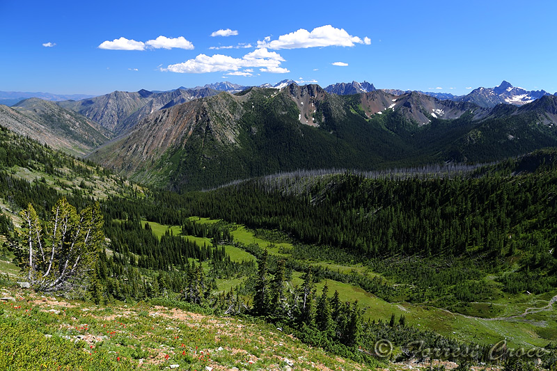
Grasshopper Pass & Tatie Peak
Harts Pass is a magical happy place, it's also where the highest road in the state ends. This is a long dirt road, with a scary and dangerous section (called Deadhorse Point), and it's 4 to 5 hours drive from Seattle. But absolutely worth doing. Be aware there's nothing up here but nature, you need to bring your own food, water, and everything else. There are two campgrounds but they do not have water.
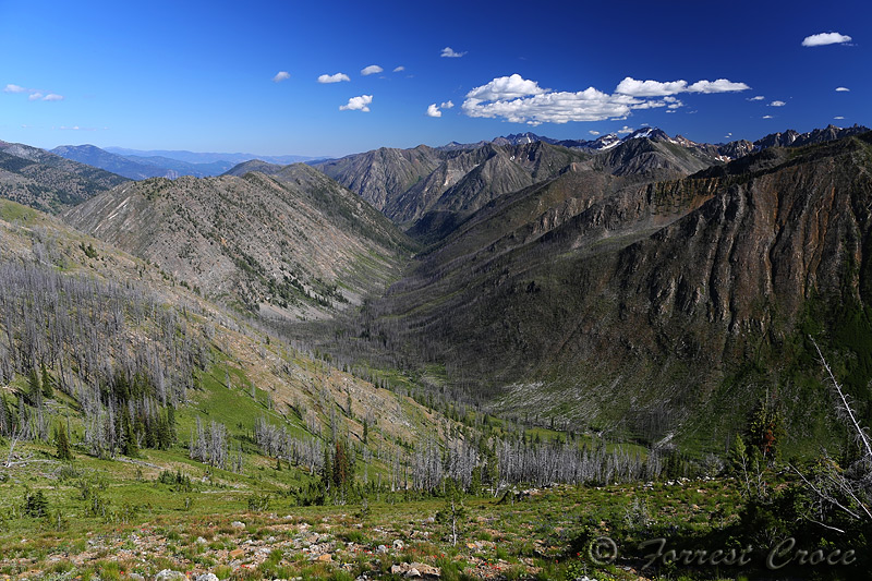
The nice thing about this area is that there are almost no trees. Most of the ones that used to live here died long ago in a fire. We'll talk about burn zones at some point, they're lovely! The area is mostly above tree line so it's mostly alpine meadow and some ghost wood.
The Pacific Crest Trail (PCT) runs through Harts Pass, it's the last road access before Canada. Grasshopper Pass is about a 5 mile hike south on the PCT, some of this is a ridge walk. Hiking north from here is lovely too, in an entirely different way.
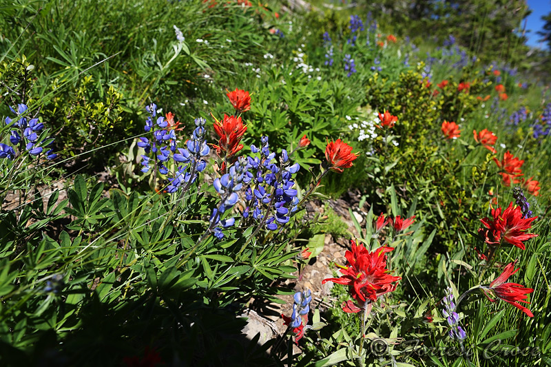
This is wildflowery in the spring and larchy in the fall.

Here's what it looks like in the fall. 5
5 -
I feel like a broken record with the larch thing, but here's another great trail you should absolutely do. Let me quote a good friend.
(1) "You haven't lived until you've been to Harts Pass."
(2) "Maple Pass is the best ridge walk in the state."
She was right on both counts.
Heather & Maple Pass Loop
This one starts on SR 20 at Rainy Pass, and it gets busy. Last year during larch season my friend and I left Seattle at 3 am to do this hike, we beat the crowds, got a good parking space, and were in an alpine meadow for sunrise. It's busy because it's effing gorgeous. This is also a great spring (June) hike because of the wildflowers in the meadow sections. Hell, it's a great any time hike because of the mountain scenery in every direction. Don't do it if you're very afraid of heights because there's a knife-edge section.
This is a high country hike, full of rock gardens and silver wood. But you'll have to trudge through a few miles of forest to get there.
There's a side trip to Ann Lake that's probably worth doing, too, but I don't have pictures online from there.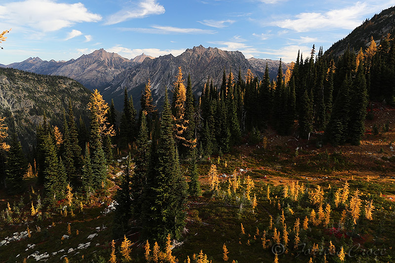

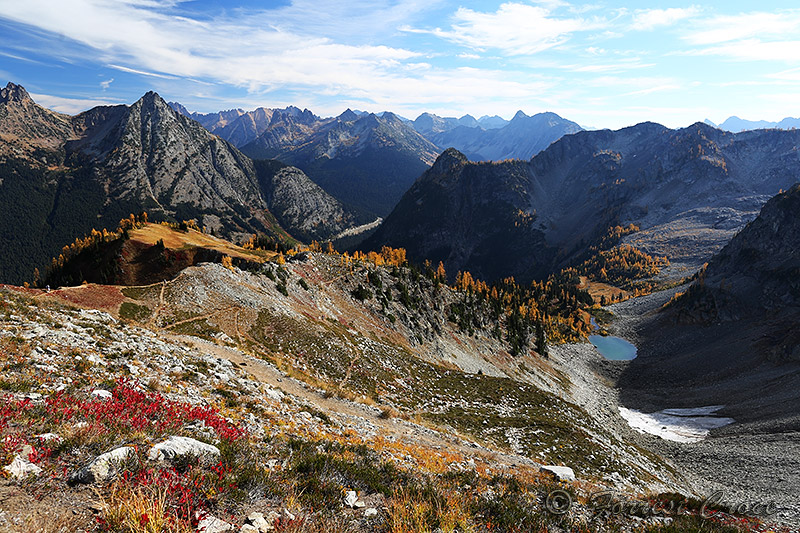
^ There was a glacier here (right edge) when you were born.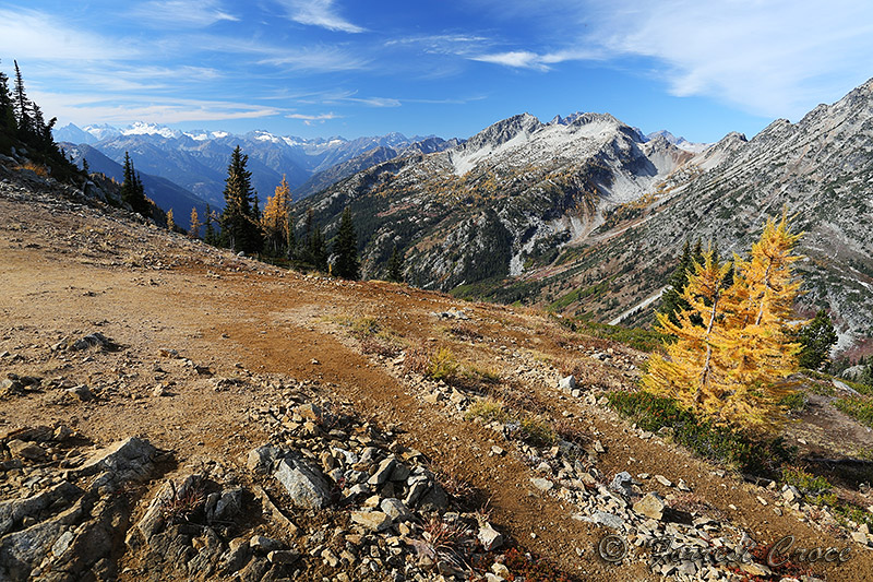
The hill in the next two pics was the local Shangri La.
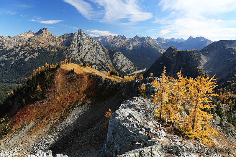
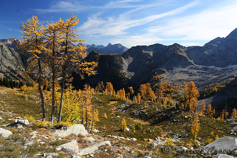
^ You can see the large glacier basin on the right, the ice melted away 20 or 30 (?) years ago, it's being colonized by larches now.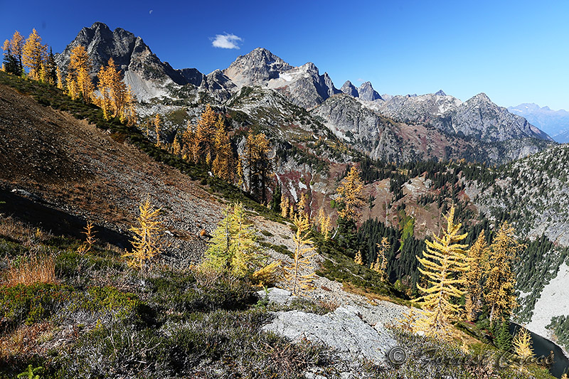 2
2 -
NorthCascades wrote: »Well the last time I went hiking I broke my ankle and had to have search and rescue bring me down. That was fun!
I hope it was free. @sireenmalik2014 should know that in our area, search and rescue is ALWAYS free, in large part for the safety of the people doing the rescue work (who are mostly volunteers). I also hope you're doing ok.
Here's a great video of a recent SAR mission on Dragontail Peak, in the Enchantment Lakes Basin near Leavenworth.sireenmalik2014 wrote: »Recent hike: Mailbox Peak, WA
You're in good shape if you did Mailbox Peak.
But I want you to make me a promise. No more "close in" hikes until the rainy season begins. I'm going to send you to more spectacular places.NorthCascades wrote: »Well the last time I went hiking I broke my ankle and had to have search and rescue bring me down. That was fun!
I hope it was free. @sireenmalik2014 should know that in our area, search and rescue is ALWAYS free, in large part for the safety of the people doing the rescue work (who are mostly volunteers). I also hope you're doing ok.
Here's a great video of a recent SAR mission on Dragontail Peak, in the Enchantment Lakes Basin near Leavenworth.sireenmalik2014 wrote: »Recent hike: Mailbox Peak, WA
You're in good shape if you did Mailbox Peak.
But I want you to make me a promise. No more "close in" hikes until the rainy season begins. I'm going to send you to more spectacular places.
0 -
SAR was free. Rescue was on mailbox.1
-
One more strong recommendation from the Harts Pass area. This place is just so spectacular. It's a very long drive but worth doing at least once (a year).
Silver Lake
This was harder for me than the numbers (miles & elevation gain) would have you believe. I live in Seattle proper, at 60 feet above sea level, so the air is just slightly thin up there, and I had a really heavy pack. I was planning to summit Pasayten Peak but decided against it when I got there.
Here's a photo from the road where I parked.


I'm a sucker for a big, wide, U-shaped glacier-carved valley.


These aren't from the hike but here are a few pics from the road in.
The Silver Lake trail makes its way through the meadows below, this is looking north from Slate Peak.
This is looking west.
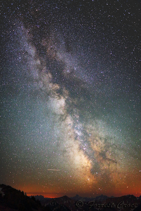
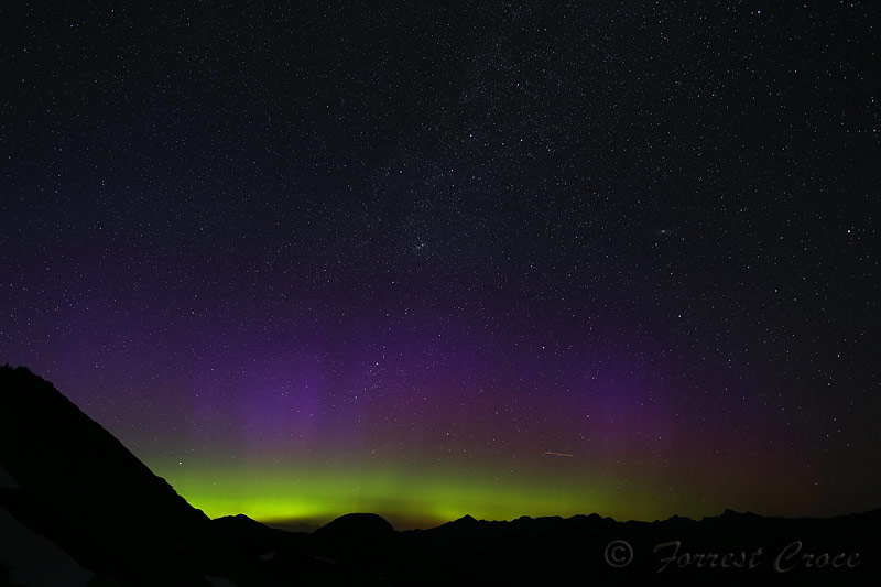
Here are some pics from camping on Slate Peak. Just next to my car. Parked my car strategically to block the wind. It was the 4th of July weekend but probably 30 F at night. There was a photographer there for a couple hours, we were chatting, and my voice went up a couple octaves every time I took my glove off to change a setting on the camera.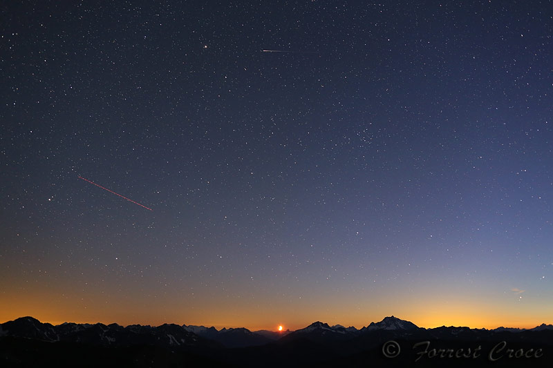
 4
4 -
Wow, @NorthCascades, thank you for posting all these pics! I've never been fortunate enough to spend any time in the NW but now it's on my short-list.2
-
I'm glad people are appreciating the pics. For the record, most of these came from a 10 pound camera system, there's been a lot of sore back involved in capturing these. I really do hope they draw my new friend @sireenmalik2014 out to new places, nobody should hike Mailbox Peak in the high summer. (Mailbox is nice, but we have jaw dropping nearby.)1
-
I just did a trip to the North Cascades last year. A big YES to Maple Pass and Grasshopper Pass. Going up and (especially) down Hart's Pass Road is very scary for me, being a flatlander from the Midwest, but it is totally worth the entire white-knuckle drive. Also, Blue Lake is a nice short trail to a pretty lake if you only have a few hours.2
-
Chelan Lakeshore Trail
This is a spring classic. This one melts very early because of the low elevation, warm climate, and west-facing aspect. When most trails are still covered in snow, this is a good option. Don't do it on Memorial Day weekend or you'll join 10,000 of your closest friends.
For this hike, you take the Lady of the Lake ferry about halfway up the lake, and get dropped off at Prince Creek or Moore Point, then hike to the tiny little town of Stehekin. You can camp there, or reserve a room at the Lodge or in some of the cabins. Then you take the ferry (or a float plane - strongly not recommended!) back to your car.

From the boat, the hills look brown, sun-burnt, and dead, but when you get close, they're teeming with life.

Never in my life have I seen so many lupines! Countless millions of them in the 17 miles along this trail.

Eventually you start to see some trees here and there, and then you come into a ponderosa forest.
Finally you reach Stehekin, and get off your feet.

These were the most terrifying 25 minutes of my life. I thought about throwing the door open and jumping to get it over with, I had no confidence our pilot would land us safely. So glad I was wrong! I would rather crawl the 50 miles on broken glass than ever do this again. 2
2 -
SuzySunshine99 wrote: »I just did a trip to the North Cascades last year. A big YES to Maple Pass and Grasshopper Pass. Going up and (especially) down Hart's Pass Road is very scary for me, being a flatlander from the Midwest, but it is totally worth the entire white-knuckle drive. Also, Blue Lake is a nice short trail to a pretty lake if you only have a few hours.
You remember the part that's just barely wider than your car, with no guard rail and a 3,000 foot drop? I punctured a tire there on a very sharp rock. Then it was 5 miles before there was a flat spot I could jack my car up over. 0
 -
NorthCascades wrote: »SuzySunshine99 wrote: »I just did a trip to the North Cascades last year. A big YES to Maple Pass and Grasshopper Pass. Going up and (especially) down Hart's Pass Road is very scary for me, being a flatlander from the Midwest, but it is totally worth the entire white-knuckle drive. Also, Blue Lake is a nice short trail to a pretty lake if you only have a few hours.
You remember the part that's just barely wider than your car, with no guard rail and a 3,000 foot drop? I punctured a tire there on a very sharp rock. Then it was 5 miles before there was a flat spot I could jack my car up over.
Oh, god, that's a nightmare. They were doing some work on the road when I was there and had to get around construction equipment. I think someone could do a nice business running a shuttle service up and down that road. I'd pay for that.0 -
@SuzySunshine99 check out the video in this thread!
http://www.nwhikers.net/forums/viewtopic.php?t=80205821 -
Horseshoe Basin (Pasayten)
There are actually a couple of Horseshoe Basins in the state, the one I'm about to show pictures from is the one in the Pasayten Wilderness, near Tonasket. There's another Horseshoe Basin on the Cascade Pass trail, it's maybe 150 miles away, one year I ran into somebody there who had intended to go to the other one. He was very frustrated. That's why I'm clarifying.
This is a magical place, it's not exactly a secret, but it's a 7 hour drive from Seattle so it's rarely crowded. We just spent three days; we saw one person on the hike in, I saw another person the next day while hiking, and nobody the third day.
There be arctic tundra here, the basin sits on a layer of permafrost, and is very boggy and poorly drained because of it. We got caught in a fierce hail storm, meanwhile it was 98 F in Tonasket.
I was impressed with the sign. We took the Boundary Trail in and out, but if you have time, I hear the Clutch Creek trail is lovely.
Trail starts off in a living forest for about 1/4 mile, then a clearing, and then about 5 lovely miles of burn zone. This area went up like a torch 10 years ago (2006 Tripod Complex fire) and the ghost trees are silvering very nicely.


Then you go over Sunny Pass, where you get a view of the rolling, wind-swept eastern Pasayten.
Then it's into the basin.

We got benighted on the trail, watched a dramatic sunset, and set up our camp in the dark by headlamp. Owls were flying all around us. The next day we saw a coyote, bear and lynx (?) scat, ptarmigan, and a heard of deer running through a meadow.

Lot of flowers here, too, but they bloom early.

Plenty of exploring and peak bagging to do here.
And then we had to leave. 2
2 -
NorthCascades wrote: »@SuzySunshine99 check out the video in this thread!
http://www.nwhikers.net/forums/viewtopic.php?t=8020582
K, thanks a bunch. Like I wasn't already pooping bricks. 0
0
Categories
- All Categories
- 1.4M Health, Wellness and Goals
- 398.2K Introduce Yourself
- 44.7K Getting Started
- 261K Health and Weight Loss
- 176.4K Food and Nutrition
- 47.7K Recipes
- 233K Fitness and Exercise
- 462 Sleep, Mindfulness and Overall Wellness
- 6.5K Goal: Maintaining Weight
- 8.7K Goal: Gaining Weight and Body Building
- 153.5K Motivation and Support
- 8.4K Challenges
- 1.4K Debate Club
- 96.5K Chit-Chat
- 2.6K Fun and Games
- 4.8K MyFitnessPal Information
- 12 News and Announcements
- 21 MyFitnessPal Academy
- 1.6K Feature Suggestions and Ideas
- 3.2K MyFitnessPal Tech Support Questions


